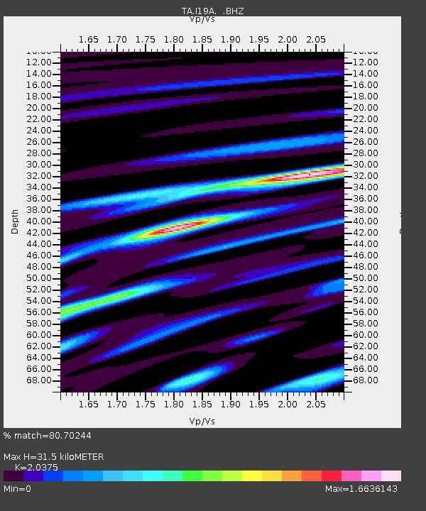
I19A Meeteetse, WY, USA - Earthquake Result Viewer

Earthquake location: Fox Islands, Aleutian Islands
Earthquake latitude/longitude: 52.9/-169.8
Earthquake time(UTC): 2010/07/18 (199) 05:56:44 GMT
Earthquake Depth: 14 km
Earthquake Magnitude: 6.3 MB, 6.7 MS, 6.6 MW, 6.6 MW
Earthquake Catalog/Contributor: WHDF/NEIC
Network: TA USArray Transportable Network (new EarthScope stations)
Station: I19A Meeteetse, WY, USA
Lat/Lon: 44.04 N/108.99 W
Elevation: 1982 m
Distance: 40.2 deg
Az: 77.429 deg
Baz: 304.89 deg
Ray Param: 0.07452407
Estimated Moho Depth: 31.5 km
Estimated Crust Vp/Vs: 2.04
Assumed Crust Vp: 6.242 km/s
Estimated Crust Vs: 3.064 km/s
Estimated Crust Poisson's Ratio: 0.34
Radial Match: 80.70244 %
Radial Bump: 400
Transverse Match: 64.78057 %
Transverse Bump: 400
SOD ConfigId: 319893
Insert Time: 2011-01-05 05:43:24.453 +0000
GWidth: 2.5
Max Bumps: 400
Tol: 0.001

Signal To Noise

ChannelStoNSTALTA
TA:I19A: :BHZ:20100718T06:03:49.875007Z21.0445842.6396954E-61.2543346E-7
TA:I19A: :BHN:20100718T06:03:49.875007Z3.7952168.809664E-72.321255E-7
TA:I19A: :BHE:20100718T06:03:49.875007Z4.7223781.1105432E-62.3516611E-7
Arrivals
Ps5.5 SECOND
PpPs14 SECOND
PsPs/PpSs20 SECOND