You are here: Home > Network List > NE - New England Seismic Network Stations List
> Station EMMW Machias, ME, USA > Earthquake Result Viewer
EMMW Machias, ME, USA - Earthquake Result Viewer
| Earthquake location: |
Morocco |
| Earthquake latitude/longitude: |
31.1/-8.4 |
| Earthquake time(UTC): |
2023/09/08 (251) 22:11:01 GMT |
| Earthquake Depth: |
19 km |
| Earthquake Magnitude: |
6.8 mww |
| Earthquake Catalog/Contributor: |
NEIC PDE/us |
|
| Network: |
NE New England Seismic Network |
| Station: |
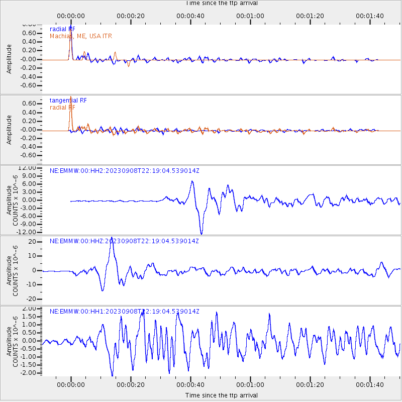
EMMW Machias, ME, USA |
| Lat/Lon: |
44.71 N/67.46 W |
| Elevation: |
35 m |
|
| Distance: |
47.5 deg |
| Az: |
304.017 deg |
| Baz: |
85.564 deg |
| Ray Param: |
0.0699191 |
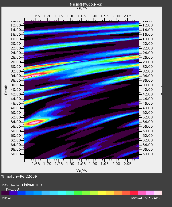
| Estimated Moho Depth: |
34.0 km |
| Estimated Crust Vp/Vs: |
1.63 |
| Assumed Crust Vp: |
6.419 km/s |
| Estimated Crust Vs: |
3.938 km/s |
| Estimated Crust Poisson's Ratio: |
0.20 |
|
| Radial Match: |
96.22009 % |
| Radial Bump: |
400 |
| Transverse Match: |
77.60396 % |
| Transverse Bump: |
400 |
| SOD ConfigId: |
31937991 |
| Insert Time: |
2023-09-22 22:39:11.387 +0000 |
| GWidth: |
2.5 |
| Max Bumps: |
400 |
| Tol: |
0.001 |
|
Signal To Noise
| Channel | StoN | STA | LTA |
| NE:EMMW:00:HHZ:20230908T22:19:04.539014Z | 6.6008334 | 1.3168954E-6 | 1.9950441E-7 |
| NE:EMMW:00:HH1:20230908T22:19:04.539014Z | 1.5867234 | 1.7285184E-7 | 1.08936334E-7 |
| NE:EMMW:00:HH2:20230908T22:19:04.539014Z | 6.6803236 | 7.1811985E-7 | 1.0749776E-7 |
| Arrivals |
| Ps | 3.6 SECOND |
| PpPs | 13 SECOND |
| PsPs/PpSs | 17 SECOND |


