You are here: Home > Network List > TA - USArray Transportable Network (new EarthScope stations) Stations List
> Station A20A Cobblestone Ranch, Loring, MT, USA > Earthquake Result Viewer
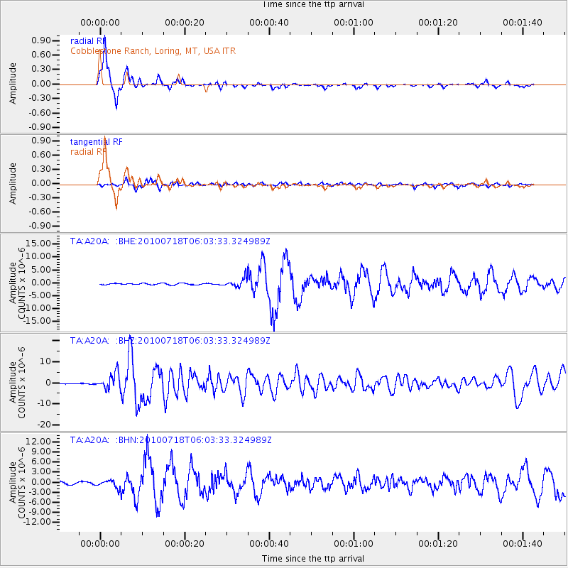
A20A Cobblestone Ranch, Loring, MT, USA - Earthquake Result Viewer

| Earthquake location: |
Fox Islands, Aleutian Islands |
| Earthquake latitude/longitude: |
52.9/-169.8 |
| Earthquake time(UTC): |
2010/07/18 (199) 05:56:44 GMT |
| Earthquake Depth: |
14 km |
| Earthquake Magnitude: |
6.3 MB, 6.7 MS, 6.6 MW, 6.6 MW |
| Earthquake Catalog/Contributor: |
WHDF/NEIC |
|
| Network: |
TA USArray Transportable Network (new EarthScope stations) |
| Station: |
A20A Cobblestone Ranch, Loring, MT, USA |
| Lat/Lon: |
48.88 N/107.93 W |
| Elevation: |
868 m |
|
| Distance: |
38.2 deg |
| Az: |
70.335 deg |
| Baz: |
300.162 deg |
| Ray Param: |
0.07568414 |
| Estimated Moho Depth: |
16.75 km |
| Estimated Crust Vp/Vs: |
1.77 |
| Assumed Crust Vp: |
6.438 km/s |
| Estimated Crust Vs: |
3.627 km/s |
| Estimated Crust Poisson's Ratio: |
0.27 |
|
| Radial Match: |
94.41221 % |
| Radial Bump: |
281 |
| Transverse Match: |
81.93906 % |
| Transverse Bump: |
400 |
| SOD ConfigId: |
319893 |
| Insert Time: |
2011-01-05 05:44:08.351 +0000 |
| GWidth: |
2.5 |
| Max Bumps: |
400 |
| Tol: |
0.001 |
|
Signal To Noise
| Channel | StoN | STA | LTA |
| TA:A20A: :BHZ:20100718T06:03:33.324989Z | 33.29153 | 3.80909E-6 | 1.1441619E-7 |
| TA:A20A: :BHN:20100718T06:03:33.324989Z | 3.2623928 | 1.0915936E-6 | 3.345991E-7 |
| TA:A20A: :BHE:20100718T06:03:33.324989Z | 5.9762416 | 1.6501517E-6 | 2.7611864E-7 |
| Arrivals |
| Ps | 2.2 SECOND |
| PpPs | 6.7 SECOND |
| PsPs/PpSs | 8.9 SECOND |


