You are here: Home > Network List > O2 - Oklahoma Consolidated Temporary Seismic Networks Stations List
> Station QUIN Quinton, Oklahoma, USA > Earthquake Result Viewer
QUIN Quinton, Oklahoma, USA - Earthquake Result Viewer
| Earthquake location: |
Morocco |
| Earthquake latitude/longitude: |
31.1/-8.4 |
| Earthquake time(UTC): |
2023/09/08 (251) 22:11:01 GMT |
| Earthquake Depth: |
19 km |
| Earthquake Magnitude: |
6.8 mww |
| Earthquake Catalog/Contributor: |
NEIC PDE/us |
|
| Network: |
O2 Oklahoma Consolidated Temporary Seismic Networks |
| Station: |
QUIN Quinton, Oklahoma, USA |
| Lat/Lon: |
35.20 N/95.47 W |
| Elevation: |
227 m |
|
| Distance: |
70.6 deg |
| Az: |
299.906 deg |
| Baz: |
65.214 deg |
| Ray Param: |
0.05484311 |
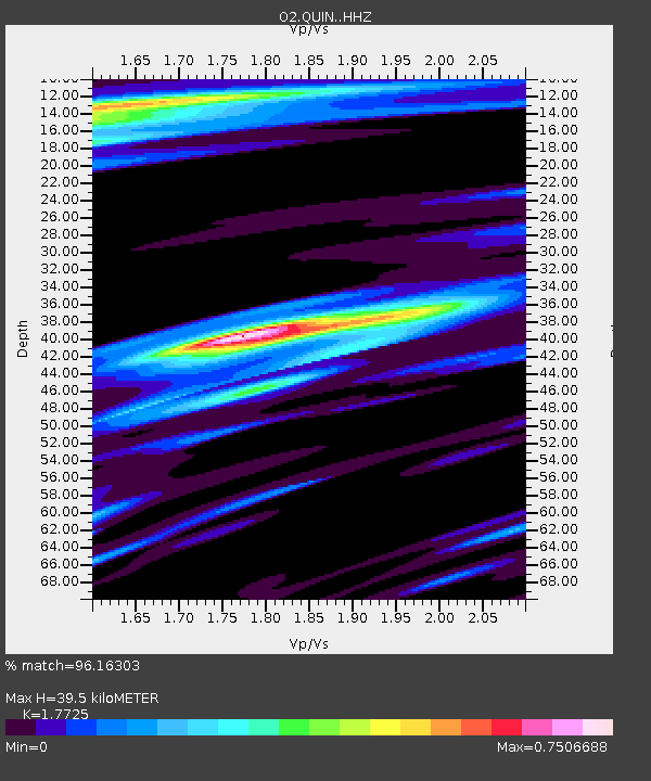
| Estimated Moho Depth: |
39.5 km |
| Estimated Crust Vp/Vs: |
1.77 |
| Assumed Crust Vp: |
6.498 km/s |
| Estimated Crust Vs: |
3.666 km/s |
| Estimated Crust Poisson's Ratio: |
0.27 |
|
| Radial Match: |
96.16303 % |
| Radial Bump: |
352 |
| Transverse Match: |
88.13306 % |
| Transverse Bump: |
400 |
| SOD ConfigId: |
31937991 |
| Insert Time: |
2023-09-22 22:41:53.864 +0000 |
| GWidth: |
2.5 |
| Max Bumps: |
400 |
| Tol: |
0.001 |
|

Signal To Noise
| Channel | StoN | STA | LTA |
| O2:QUIN: :HHZ:20230908T22:21:44.464979Z | 3.9134 | 5.3545534E-7 | 1.3682613E-7 |
| O2:QUIN: :HHN:20230908T22:21:44.464979Z | 1.5306283 | 1.6613483E-7 | 1.08540284E-7 |
| O2:QUIN: :HHE:20230908T22:21:44.464979Z | 0.8302382 | 1.1974592E-7 | 1.442308E-7 |
| Arrivals |
| Ps | 4.9 SECOND |
| PpPs | 16 SECOND |
| PsPs/PpSs | 21 SECOND |


