You are here: Home > Network List > O2 - Oklahoma Consolidated Temporary Seismic Networks Stations List
> Station SC20 Lookeba, Oklahoma, USA > Earthquake Result Viewer
SC20 Lookeba, Oklahoma, USA - Earthquake Result Viewer
| Earthquake location: |
Morocco |
| Earthquake latitude/longitude: |
31.1/-8.4 |
| Earthquake time(UTC): |
2023/09/08 (251) 22:11:01 GMT |
| Earthquake Depth: |
19 km |
| Earthquake Magnitude: |
6.8 mww |
| Earthquake Catalog/Contributor: |
NEIC PDE/us |
|
| Network: |
O2 Oklahoma Consolidated Temporary Seismic Networks |
| Station: |
SC20 Lookeba, Oklahoma, USA |
| Lat/Lon: |
35.40 N/98.44 W |
| Elevation: |
490 m |
|
| Distance: |
72.8 deg |
| Az: |
301.196 deg |
| Baz: |
63.909 deg |
| Ray Param: |
0.05345011 |
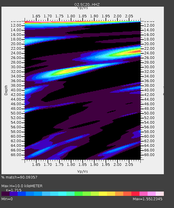
| Estimated Moho Depth: |
10.0 km |
| Estimated Crust Vp/Vs: |
1.72 |
| Assumed Crust Vp: |
6.315 km/s |
| Estimated Crust Vs: |
3.682 km/s |
| Estimated Crust Poisson's Ratio: |
0.24 |
|
| Radial Match: |
90.09357 % |
| Radial Bump: |
400 |
| Transverse Match: |
78.836945 % |
| Transverse Bump: |
400 |
| SOD ConfigId: |
31937991 |
| Insert Time: |
2023-09-22 22:42:24.768 +0000 |
| GWidth: |
2.5 |
| Max Bumps: |
400 |
| Tol: |
0.001 |
|

Signal To Noise
| Channel | StoN | STA | LTA |
| O2:SC20: :HHZ:20230908T22:21:57.120008Z | 2.973668 | 7.5137984E-7 | 2.5267778E-7 |
| O2:SC20: :HHN:20230908T22:21:57.120008Z | 0.67186147 | 1.4320516E-7 | 2.1314685E-7 |
| O2:SC20: :HHE:20230908T22:21:57.120008Z | 1.3233014 | 2.7030936E-7 | 2.0426893E-7 |
| Arrivals |
| Ps | 1.2 SECOND |
| PpPs | 4.2 SECOND |
| PsPs/PpSs | 5.3 SECOND |


