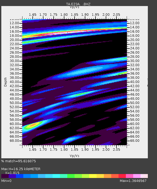
E23A Ismay, MT, USA - Earthquake Result Viewer
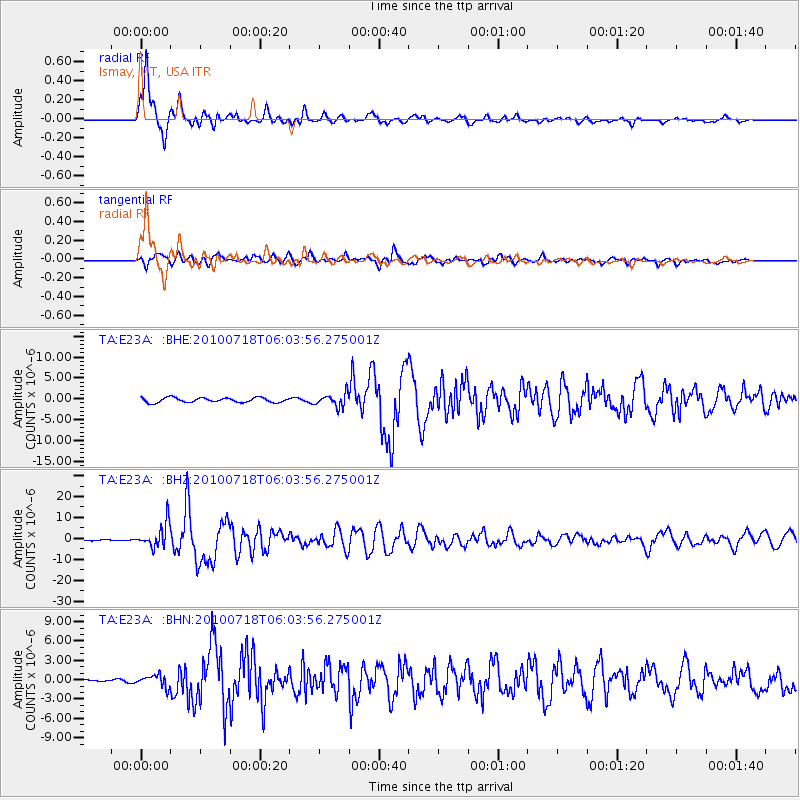
Earthquake location: Fox Islands, Aleutian Islands
Earthquake latitude/longitude: 52.9/-169.8
Earthquake time(UTC): 2010/07/18 (199) 05:56:44 GMT
Earthquake Depth: 14 km
Earthquake Magnitude: 6.3 MB, 6.7 MS, 6.6 MW, 6.6 MW
Earthquake Catalog/Contributor: WHDF/NEIC
Network: TA USArray Transportable Network (new EarthScope stations)
Station: E23A Ismay, MT, USA
Lat/Lon: 46.50 N/105.31 W
Elevation: 750 m
Distance: 41.0 deg
Az: 72.05 deg
Baz: 303.416 deg
Ray Param: 0.07407396
Estimated Moho Depth: 16.25 km
Estimated Crust Vp/Vs: 1.82
Assumed Crust Vp: 6.438 km/s
Estimated Crust Vs: 3.547 km/s
Estimated Crust Poisson's Ratio: 0.28
Radial Match: 95.616875 %
Radial Bump: 400
Transverse Match: 84.53816 %
Transverse Bump: 400
SOD ConfigId: 319893
Insert Time: 2011-01-05 05:45:35.181 +0000
GWidth: 2.5
Max Bumps: 400
Tol: 0.001

Signal To Noise

ChannelStoNSTALTA
TA:E23A: :BHZ:20100718T06:03:56.275001Z29.8244675.7006955E-61.9114157E-7
TA:E23A: :BHN:20100718T06:03:56.275001Z3.67558678.985382E-72.4446115E-7
TA:E23A: :BHE:20100718T06:03:56.275001Z2.72099041.5216466E-65.5922527E-7
Arrivals
Ps2.2 SECOND
PpPs6.6 SECOND
PsPs/PpSs8.8 SECOND