You are here: Home > Network List > PQ - Public Safety Geoscience Program Canadian Research Network (PSGP) Stations List
> Station ULUN Ulukhaktok, Victoria Island, NWT, Canada > Earthquake Result Viewer
ULUN Ulukhaktok, Victoria Island, NWT, Canada - Earthquake Result Viewer
| Earthquake location: |
Morocco |
| Earthquake latitude/longitude: |
31.1/-8.4 |
| Earthquake time(UTC): |
2023/09/08 (251) 22:11:01 GMT |
| Earthquake Depth: |
19 km |
| Earthquake Magnitude: |
6.8 mww |
| Earthquake Catalog/Contributor: |
NEIC PDE/us |
|
| Network: |
PQ Public Safety Geoscience Program Canadian Research Network (PSGP) |
| Station: |
ULUN Ulukhaktok, Victoria Island, NWT, Canada |
| Lat/Lon: |
70.74 N/117.76 W |
| Elevation: |
5.0 m |
|
| Distance: |
67.0 deg |
| Az: |
340.107 deg |
| Baz: |
61.562 deg |
| Ray Param: |
0.057227623 |
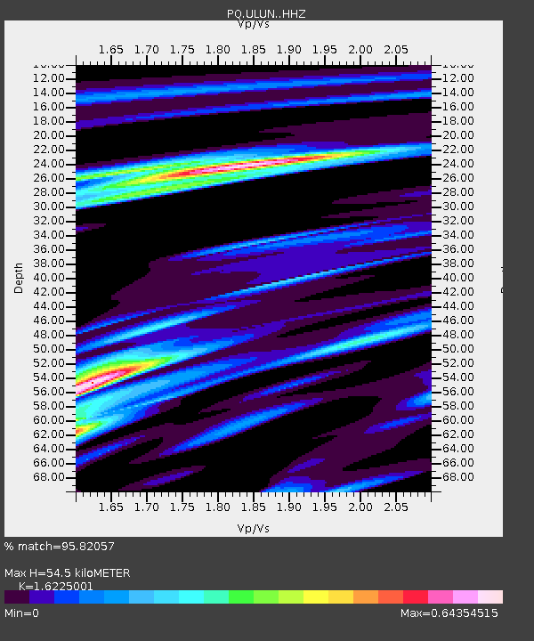
| Estimated Moho Depth: |
54.5 km |
| Estimated Crust Vp/Vs: |
1.62 |
| Assumed Crust Vp: |
6.367 km/s |
| Estimated Crust Vs: |
3.924 km/s |
| Estimated Crust Poisson's Ratio: |
0.19 |
|
| Radial Match: |
95.82057 % |
| Radial Bump: |
322 |
| Transverse Match: |
80.2735 % |
| Transverse Bump: |
400 |
| SOD ConfigId: |
31937991 |
| Insert Time: |
2023-09-22 22:44:47.374 +0000 |
| GWidth: |
2.5 |
| Max Bumps: |
400 |
| Tol: |
0.001 |
|

Signal To Noise
| Channel | StoN | STA | LTA |
| PQ:ULUN: :HHZ:20230908T22:21:21.82002Z | 7.4376597 | 1.960827E-6 | 2.6363492E-7 |
| PQ:ULUN: :HHN:20230908T22:21:21.82002Z | 3.2798603 | 4.5259642E-7 | 1.3799259E-7 |
| PQ:ULUN: :HHE:20230908T22:21:21.82002Z | 4.65421 | 8.271042E-7 | 1.7771096E-7 |
| Arrivals |
| Ps | 5.6 SECOND |
| PpPs | 22 SECOND |
| PsPs/PpSs | 27 SECOND |


