You are here: Home > Network List > TA - USArray Transportable Network (new EarthScope stations) Stations List
> Station N26A Koester Ranch, Padroni, CO, USA > Earthquake Result Viewer
N26A Koester Ranch, Padroni, CO, USA - Earthquake Result Viewer
| Earthquake location: |
Fox Islands, Aleutian Islands |
| Earthquake latitude/longitude: |
52.9/-169.8 |
| Earthquake time(UTC): |
2010/07/18 (199) 05:56:44 GMT |
| Earthquake Depth: |
14 km |
| Earthquake Magnitude: |
6.3 MB, 6.7 MS, 6.6 MW, 6.6 MW |
| Earthquake Catalog/Contributor: |
WHDF/NEIC |
|
| Network: |
TA USArray Transportable Network (new EarthScope stations) |
| Station: |
N26A Koester Ranch, Padroni, CO, USA |
| Lat/Lon: |
40.83 N/103.22 W |
| Elevation: |
1284 m |
|
| Distance: |
45.5 deg |
| Az: |
77.431 deg |
| Baz: |
308.775 deg |
| Ray Param: |
0.07120418 |
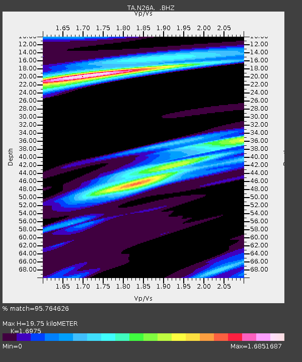
| Estimated Moho Depth: |
19.75 km |
| Estimated Crust Vp/Vs: |
1.70 |
| Assumed Crust Vp: |
6.483 km/s |
| Estimated Crust Vs: |
3.819 km/s |
| Estimated Crust Poisson's Ratio: |
0.23 |
|
| Radial Match: |
95.764626 % |
| Radial Bump: |
206 |
| Transverse Match: |
72.4684 % |
| Transverse Bump: |
386 |
| SOD ConfigId: |
319893 |
| Insert Time: |
2011-01-05 05:47:27.032 +0000 |
| GWidth: |
2.5 |
| Max Bumps: |
400 |
| Tol: |
0.001 |
|

Signal To Noise
| Channel | StoN | STA | LTA |
| TA:N26A: :BHZ:20100718T06:04:33.100013Z | 27.38779 | 5.589643E-6 | 2.0409252E-7 |
| TA:N26A: :BHN:20100718T06:04:33.100013Z | 2.7945664 | 9.533812E-7 | 3.4115533E-7 |
| TA:N26A: :BHE:20100718T06:04:33.100013Z | 4.3677936 | 1.2420691E-6 | 2.843699E-7 |
| Arrivals |
| Ps | 2.3 SECOND |
| PpPs | 7.7 SECOND |
| PsPs/PpSs | 10.0 SECOND |


