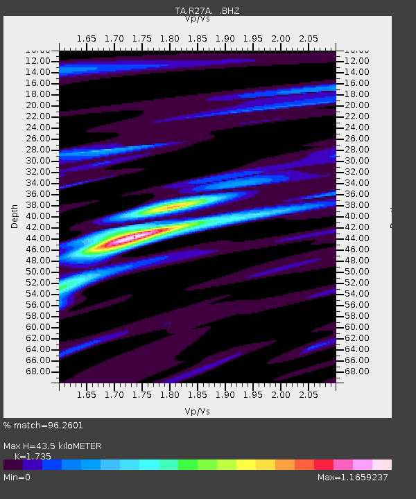
R27A Eads, CO, USA - Earthquake Result Viewer

Earthquake location: Fox Islands, Aleutian Islands
Earthquake latitude/longitude: 52.9/-169.8
Earthquake time(UTC): 2010/07/18 (199) 05:56:44 GMT
Earthquake Depth: 14 km
Earthquake Magnitude: 6.3 MB, 6.7 MS, 6.6 MW, 6.6 MW
Earthquake Catalog/Contributor: WHDF/NEIC
Network: TA USArray Transportable Network (new EarthScope stations)
Station: R27A Eads, CO, USA
Lat/Lon: 38.29 N/102.80 W
Elevation: 1201 m
Distance: 47.4 deg
Az: 79.835 deg
Baz: 310.701 deg
Ray Param: 0.06999795
Estimated Moho Depth: 43.5 km
Estimated Crust Vp/Vs: 1.74
Assumed Crust Vp: 6.242 km/s
Estimated Crust Vs: 3.598 km/s
Estimated Crust Poisson's Ratio: 0.25
Radial Match: 96.2601 %
Radial Bump: 264
Transverse Match: 89.34616 %
Transverse Bump: 400
SOD ConfigId: 319893
Insert Time: 2011-01-05 05:47:31.053 +0000
GWidth: 2.5
Max Bumps: 400
Tol: 0.001

Signal To Noise

ChannelStoNSTALTA
TA:R27A: :BHZ:20100718T06:04:47.799995Z21.8138484.6705445E-62.1410915E-7
TA:R27A: :BHN:20100718T06:04:47.799995Z11.6842381.2662593E-61.0837329E-7
TA:R27A: :BHE:20100718T06:04:47.799995Z13.7661361.9317827E-61.4032861E-7
Arrivals
Ps5.4 SECOND
PpPs18 SECOND
PsPs/PpSs23 SECOND