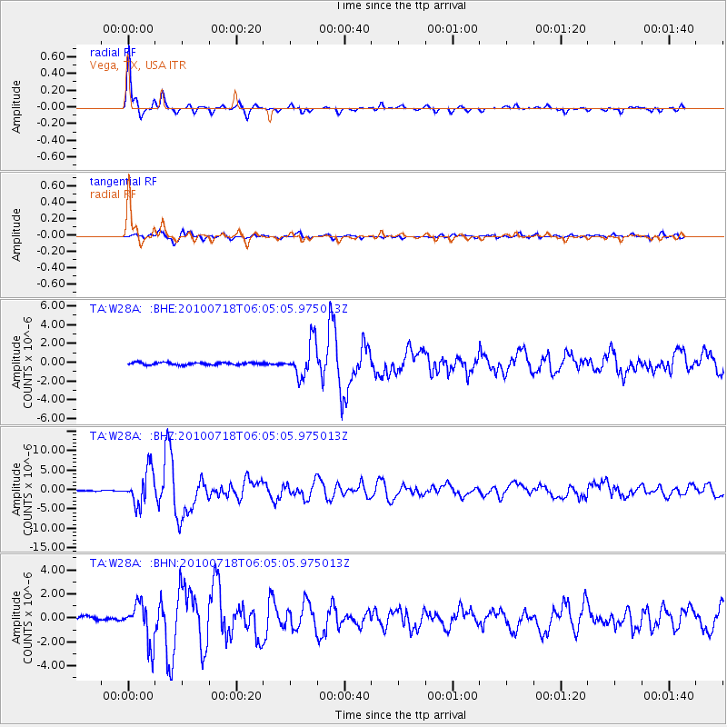
W28A Vega, TX, USA - Earthquake Result Viewer
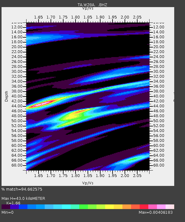
Earthquake location: Fox Islands, Aleutian Islands
Earthquake latitude/longitude: 52.9/-169.8
Earthquake time(UTC): 2010/07/18 (199) 05:56:44 GMT
Earthquake Depth: 14 km
Earthquake Magnitude: 6.3 MB, 6.7 MS, 6.6 MW, 6.6 MW
Earthquake Catalog/Contributor: WHDF/NEIC
Network: TA USArray Transportable Network (new EarthScope stations)
Station: W28A Vega, TX, USA
Lat/Lon: 35.26 N/102.21 W
Elevation: 1156 m
Distance: 49.8 deg
Az: 82.421 deg
Baz: 312.764 deg
Ray Param: 0.068475045
Estimated Moho Depth: 43.0 km
Estimated Crust Vp/Vs: 1.66
Assumed Crust Vp: 6.242 km/s
Estimated Crust Vs: 3.76 km/s
Estimated Crust Poisson's Ratio: 0.22
Radial Match: 94.662575 %
Radial Bump: 284
Transverse Match: 87.023315 %
Transverse Bump: 400
SOD ConfigId: 319893
Insert Time: 2011-01-05 05:47:55.568 +0000
GWidth: 2.5
Max Bumps: 400
Tol: 0.001

Signal To Noise

ChannelStoNSTALTA
TA:W28A: :BHZ:20100718T06:05:05.975013Z30.0420444.407826E-61.467219E-7
TA:W28A: :BHN:20100718T06:05:05.975013Z9.7820981.6789463E-61.7163458E-7
TA:W28A: :BHE:20100718T06:05:05.975013Z14.5667641.875134E-61.2872688E-7
Arrivals
Ps4.8 SECOND
PpPs17 SECOND
PsPs/PpSs22 SECOND