X28A Dimmitt, TX, USA - Earthquake Result Viewer
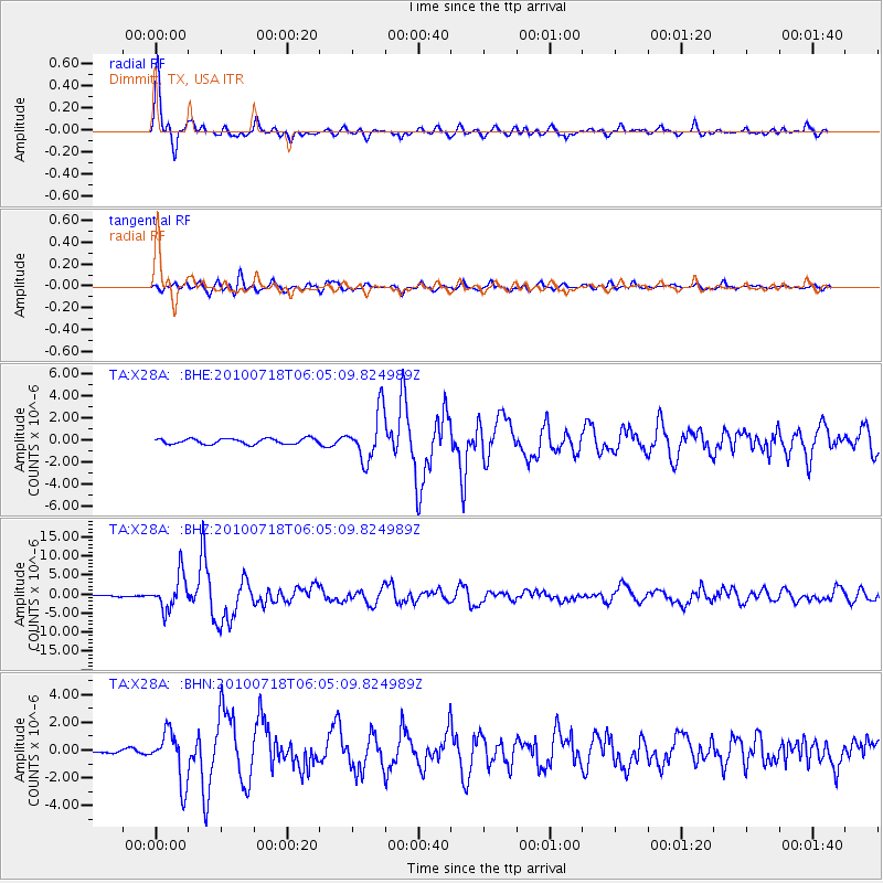
Earthquake location: Fox Islands, Aleutian Islands
Earthquake latitude/longitude: 52.9/-169.8
Earthquake time(UTC): 2010/07/18 (199) 05:56:44 GMT
Earthquake Depth: 14 km
Earthquake Magnitude: 6.3 MB, 6.7 MS, 6.6 MW, 6.6 MW
Earthquake Catalog/Contributor: WHDF/NEIC
Network: TA USArray Transportable Network (new EarthScope stations)
Station: X28A Dimmitt, TX, USA
Lat/Lon: 34.52 N/102.20 W
Elevation: 1160 m
Distance: 50.3 deg
Az: 83.118 deg
Baz: 313.217 deg
Ray Param: 0.068149745
Estimated Moho Depth: 35.25 km
Estimated Crust Vp/Vs: 1.88
Assumed Crust Vp: 6.242 km/s
Estimated Crust Vs: 3.32 km/s
Estimated Crust Poisson's Ratio: 0.30
Radial Match: 94.606255 %
Radial Bump: 398
Transverse Match: 82.104706 %
Transverse Bump: 400
SOD ConfigId: 319893
Insert Time: 2011-01-05 05:48:07.734 +0000
GWidth: 2.5
Max Bumps: 400
Tol: 0.001

Signal To Noise

ChannelStoNSTALTA
TA:X28A: :BHZ:20100718T06:05:09.824989Z22.319224.480361E-62.0074003E-7
TA:X28A: :BHN:20100718T06:05:09.824989Z16.3545821.8141558E-61.1092646E-7
TA:X28A: :BHE:20100718T06:05:09.824989Z8.9701362.1993887E-62.4519014E-7
Arrivals
Ps5.2 SECOND
PpPs15 SECOND
PsPs/PpSs21 SECOND