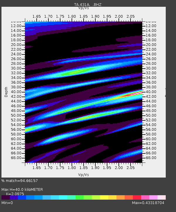
431A Sonora, TX, USA - Earthquake Result Viewer

Earthquake location: Fox Islands, Aleutian Islands
Earthquake latitude/longitude: 52.9/-169.8
Earthquake time(UTC): 2010/07/18 (199) 05:56:44 GMT
Earthquake Depth: 14 km
Earthquake Magnitude: 6.3 MB, 6.7 MS, 6.6 MW, 6.6 MW
Earthquake Catalog/Contributor: WHDF/NEIC
Network: TA USArray Transportable Network (new EarthScope stations)
Station: 431A Sonora, TX, USA
Lat/Lon: 30.68 N/100.61 W
Elevation: 700 m
Distance: 53.9 deg
Az: 85.396 deg
Baz: 315.47 deg
Ray Param: 0.065767765
Estimated Moho Depth: 40.0 km
Estimated Crust Vp/Vs: 2.10
Assumed Crust Vp: 6.38 km/s
Estimated Crust Vs: 3.042 km/s
Estimated Crust Poisson's Ratio: 0.35
Radial Match: 94.66157 %
Radial Bump: 400
Transverse Match: 86.99417 %
Transverse Bump: 400
SOD ConfigId: 319893
Insert Time: 2011-01-05 05:49:36.233 +0000
GWidth: 2.5
Max Bumps: 400
Tol: 0.001

Signal To Noise

ChannelStoNSTALTA
TA:431A: :BHZ:20100718T06:05:36.82502Z59.2012335.8370974E-69.859756E-8
TA:431A: :BHN:20100718T06:05:36.82502Z25.3951281.909519E-67.519234E-8
TA:431A: :BHE:20100718T06:05:36.82502Z13.9329752.0154052E-61.4465003E-7
Arrivals
Ps7.2 SECOND
PpPs19 SECOND
PsPs/PpSs26 SECOND