You are here: Home > Network List > UW - Pacific Northwest Regional Seismic Network Stations List
> Station CVILL Solar Farm Field, Colville, WA, USA > Earthquake Result Viewer
CVILL Solar Farm Field, Colville, WA, USA - Earthquake Result Viewer
| Earthquake location: |
Morocco |
| Earthquake latitude/longitude: |
31.1/-8.4 |
| Earthquake time(UTC): |
2023/09/08 (251) 22:11:01 GMT |
| Earthquake Depth: |
19 km |
| Earthquake Magnitude: |
6.8 mww |
| Earthquake Catalog/Contributor: |
NEIC PDE/us |
|
| Network: |
UW Pacific Northwest Regional Seismic Network |
| Station: |
CVILL Solar Farm Field, Colville, WA, USA |
| Lat/Lon: |
48.55 N/117.87 W |
| Elevation: |
581 m |
|
| Distance: |
78.8 deg |
| Az: |
320.3 deg |
| Baz: |
55.55 deg |
| Ray Param: |
0.04940081 |
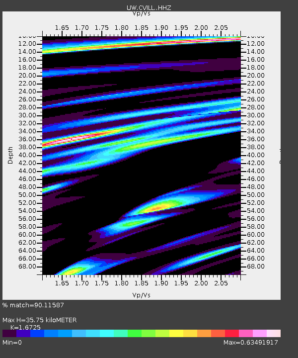
| Estimated Moho Depth: |
35.75 km |
| Estimated Crust Vp/Vs: |
1.67 |
| Assumed Crust Vp: |
6.571 km/s |
| Estimated Crust Vs: |
3.929 km/s |
| Estimated Crust Poisson's Ratio: |
0.22 |
|
| Radial Match: |
90.11587 % |
| Radial Bump: |
400 |
| Transverse Match: |
78.94057 % |
| Transverse Bump: |
400 |
| SOD ConfigId: |
31937991 |
| Insert Time: |
2023-09-22 22:53:17.865 +0000 |
| GWidth: |
2.5 |
| Max Bumps: |
400 |
| Tol: |
0.001 |
|

Signal To Noise
| Channel | StoN | STA | LTA |
| UW:CVILL: :HHZ:20230908T22:22:31.459974Z | 9.699326 | 1.022348E-6 | 1.0540403E-7 |
| UW:CVILL: :HHN:20230908T22:22:31.459974Z | 1.1459414 | 1.5606507E-7 | 1.361894E-7 |
| UW:CVILL: :HHE:20230908T22:22:31.459974Z | 2.5710845 | 3.959846E-7 | 1.5401463E-7 |
| Arrivals |
| Ps | 3.8 SECOND |
| PpPs | 14 SECOND |
| PsPs/PpSs | 18 SECOND |


