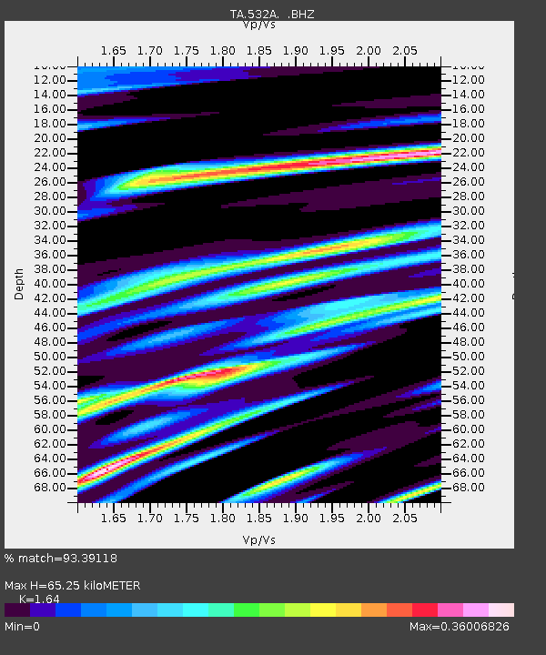
532A Rocksprings, TX, USA - Earthquake Result Viewer
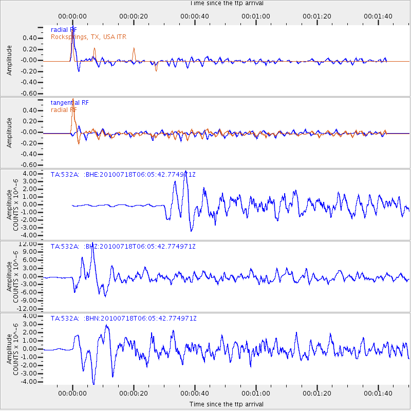
Earthquake location: Fox Islands, Aleutian Islands
Earthquake latitude/longitude: 52.9/-169.8
Earthquake time(UTC): 2010/07/18 (199) 05:56:44 GMT
Earthquake Depth: 14 km
Earthquake Magnitude: 6.3 MB, 6.7 MS, 6.6 MW, 6.6 MW
Earthquake Catalog/Contributor: WHDF/NEIC
Network: TA USArray Transportable Network (new EarthScope stations)
Station: 532A Rocksprings, TX, USA
Lat/Lon: 30.13 N/99.90 W
Elevation: 703 m
Distance: 54.7 deg
Az: 85.337 deg
Baz: 315.79 deg
Ray Param: 0.06524902
Estimated Moho Depth: 65.25 km
Estimated Crust Vp/Vs: 1.64
Assumed Crust Vp: 6.498 km/s
Estimated Crust Vs: 3.962 km/s
Estimated Crust Poisson's Ratio: 0.20
Radial Match: 93.39118 %
Radial Bump: 400
Transverse Match: 85.13527 %
Transverse Bump: 400
SOD ConfigId: 319893
Insert Time: 2011-01-05 05:50:06.497 +0000
GWidth: 2.5
Max Bumps: 400
Tol: 0.001

Signal To Noise

ChannelStoNSTALTA
TA:532A: :BHZ:20100718T06:05:42.774971Z39.3804863.2422631E-68.233172E-8
TA:532A: :BHN:20100718T06:05:42.774971Z17.8269711.3039614E-67.314542E-8
TA:532A: :BHE:20100718T06:05:42.774971Z18.4811231.4964683E-68.09728E-8
Arrivals
Ps6.8 SECOND
PpPs25 SECOND
PsPs/PpSs32 SECOND