You are here: Home > Network List > US - United States National Seismic Network Stations List
> Station DGMT Dagmar, Montana, USA > Earthquake Result Viewer
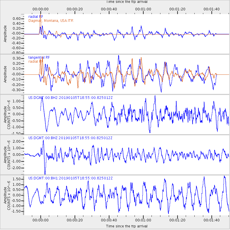
DGMT Dagmar, Montana, USA - Earthquake Result Viewer
*The percent match for this event was below the threshold and hence no stack was calculated.
| Earthquake location: |
Andreanof Islands, Aleutian Is. |
| Earthquake latitude/longitude: |
51.0/-178.2 |
| Earthquake time(UTC): |
2019/01/05 (005) 18:47:11 GMT |
| Earthquake Depth: |
35 km |
| Earthquake Magnitude: |
6.0 Mi |
| Earthquake Catalog/Contributor: |
NEIC PDE/at |
|
| Network: |
US United States National Seismic Network |
| Station: |
DGMT Dagmar, Montana, USA |
| Lat/Lon: |
48.47 N/104.20 W |
| Elevation: |
0.0 m |
|
| Distance: |
46.1 deg |
| Az: |
62.712 deg |
| Baz: |
302.418 deg |
| Ray Param: |
$rayparam |
*The percent match for this event was below the threshold and hence was not used in the summary stack. |
|
| Radial Match: |
42.003494 % |
| Radial Bump: |
312 |
| Transverse Match: |
71.87107 % |
| Transverse Bump: |
380 |
| SOD ConfigId: |
3201911 |
| Insert Time: |
2019-01-19 19:02:34.979 +0000 |
| GWidth: |
2.5 |
| Max Bumps: |
400 |
| Tol: |
0.001 |
|
Signal To Noise
| Channel | StoN | STA | LTA |
| US:DGMT:00:BHZ:20190105T18:55:00.825012Z | 5.720574 | 1.2222401E-6 | 2.1365692E-7 |
| US:DGMT:00:BH1:20190105T18:55:00.825012Z | 0.798438 | 5.71098E-7 | 7.152691E-7 |
| US:DGMT:00:BH2:20190105T18:55:00.825012Z | 1.0713966 | 5.481205E-7 | 5.115944E-7 |
| Arrivals |
| Ps | |
| PpPs | |
| PsPs/PpSs | |


