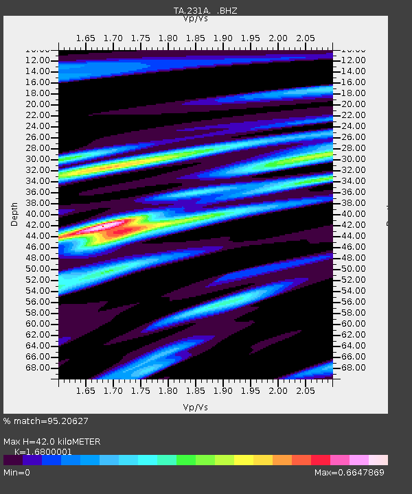
231A Bronte, TX, USA - Earthquake Result Viewer
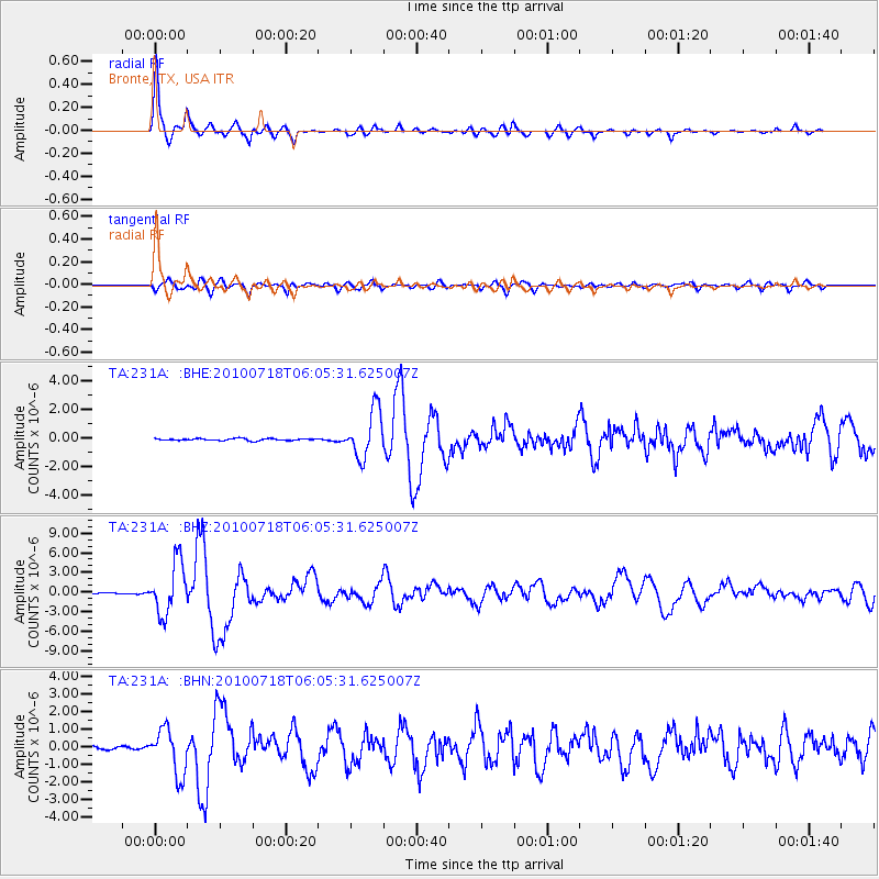
Earthquake location: Fox Islands, Aleutian Islands
Earthquake latitude/longitude: 52.9/-169.8
Earthquake time(UTC): 2010/07/18 (199) 05:56:44 GMT
Earthquake Depth: 14 km
Earthquake Magnitude: 6.3 MB, 6.7 MS, 6.6 MW, 6.6 MW
Earthquake Catalog/Contributor: WHDF/NEIC
Network: TA USArray Transportable Network (new EarthScope stations)
Station: 231A Bronte, TX, USA
Lat/Lon: 31.94 N/100.32 W
Elevation: 574 m
Distance: 53.2 deg
Az: 84.081 deg
Baz: 314.84 deg
Ray Param: 0.06624349
Estimated Moho Depth: 42.0 km
Estimated Crust Vp/Vs: 1.68
Assumed Crust Vp: 6.38 km/s
Estimated Crust Vs: 3.798 km/s
Estimated Crust Poisson's Ratio: 0.23
Radial Match: 95.20627 %
Radial Bump: 358
Transverse Match: 86.13748 %
Transverse Bump: 400
SOD ConfigId: 319893
Insert Time: 2011-01-05 05:50:18.067 +0000
GWidth: 2.5
Max Bumps: 400
Tol: 0.001

Signal To Noise

ChannelStoNSTALTA
TA:231A: :BHZ:20100718T06:05:31.625007Z50.494133.9373963E-67.797731E-8
TA:231A: :BHN:20100718T06:05:31.625007Z11.1162071.2904273E-61.1608522E-7
TA:231A: :BHE:20100718T06:05:31.625007Z24.607621.6460806E-66.689312E-8
Arrivals
Ps4.7 SECOND
PpPs17 SECOND
PsPs/PpSs21 SECOND