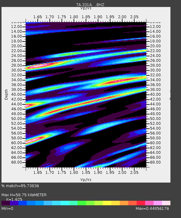
331A San Angelo, TX, USA - Earthquake Result Viewer
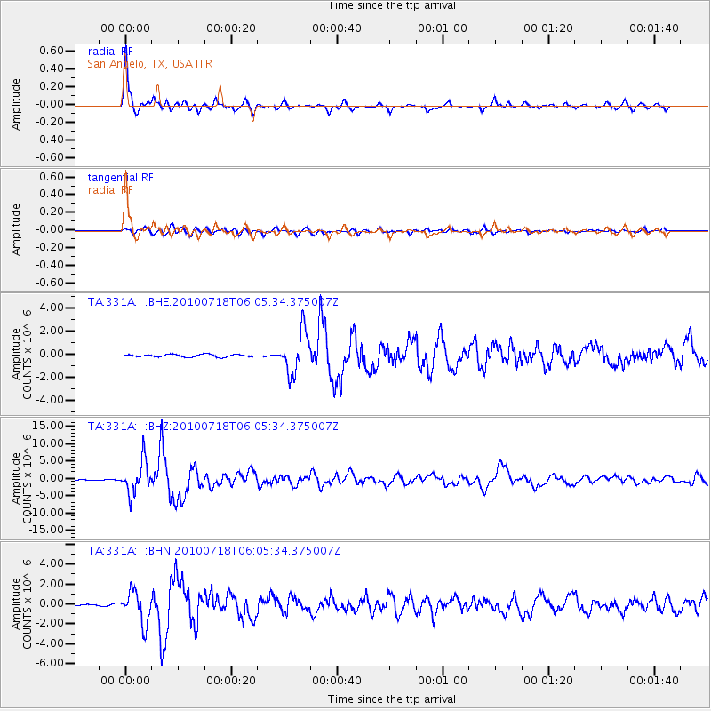
Earthquake location: Fox Islands, Aleutian Islands
Earthquake latitude/longitude: 52.9/-169.8
Earthquake time(UTC): 2010/07/18 (199) 05:56:44 GMT
Earthquake Depth: 14 km
Earthquake Magnitude: 6.3 MB, 6.7 MS, 6.6 MW, 6.6 MW
Earthquake Catalog/Contributor: WHDF/NEIC
Network: TA USArray Transportable Network (new EarthScope stations)
Station: 331A San Angelo, TX, USA
Lat/Lon: 31.31 N/100.43 W
Elevation: 615 m
Distance: 53.6 deg
Az: 84.714 deg
Baz: 315.16 deg
Ray Param: 0.065991856
Estimated Moho Depth: 58.75 km
Estimated Crust Vp/Vs: 1.62
Assumed Crust Vp: 6.38 km/s
Estimated Crust Vs: 3.926 km/s
Estimated Crust Poisson's Ratio: 0.20
Radial Match: 95.73836 %
Radial Bump: 308
Transverse Match: 86.27441 %
Transverse Bump: 400
SOD ConfigId: 319893
Insert Time: 2011-01-05 05:50:34.019 +0000
GWidth: 2.5
Max Bumps: 400
Tol: 0.001

Signal To Noise

ChannelStoNSTALTA
TA:331A: :BHZ:20100718T06:05:34.375007Z52.5507354.6531395E-68.854566E-8
TA:331A: :BHN:20100718T06:05:34.375007Z25.63051.5998559E-66.242E-8
TA:331A: :BHE:20100718T06:05:34.375007Z16.0498391.7930608E-61.1171831E-7
Arrivals
Ps6.1 SECOND
PpPs23 SECOND
PsPs/PpSs29 SECOND