You are here: Home > Network List > TA - USArray Transportable Network (new EarthScope stations) Stations List
> Station W31A Holland Ranch, Erick, OK, USA > Earthquake Result Viewer
W31A Holland Ranch, Erick, OK, USA - Earthquake Result Viewer
| Earthquake location: |
Fox Islands, Aleutian Islands |
| Earthquake latitude/longitude: |
52.9/-169.8 |
| Earthquake time(UTC): |
2010/07/18 (199) 05:56:44 GMT |
| Earthquake Depth: |
14 km |
| Earthquake Magnitude: |
6.3 MB, 6.7 MS, 6.6 MW, 6.6 MW |
| Earthquake Catalog/Contributor: |
WHDF/NEIC |
|
| Network: |
TA USArray Transportable Network (new EarthScope stations) |
| Station: |
W31A Holland Ranch, Erick, OK, USA |
| Lat/Lon: |
35.19 N/99.94 W |
| Elevation: |
644 m |
|
| Distance: |
51.2 deg |
| Az: |
80.853 deg |
| Baz: |
313.066 deg |
| Ray Param: |
0.06756472 |
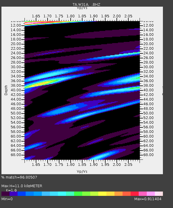
| Estimated Moho Depth: |
11.0 km |
| Estimated Crust Vp/Vs: |
1.60 |
| Assumed Crust Vp: |
6.315 km/s |
| Estimated Crust Vs: |
3.947 km/s |
| Estimated Crust Poisson's Ratio: |
0.18 |
|
| Radial Match: |
96.80507 % |
| Radial Bump: |
284 |
| Transverse Match: |
91.27603 % |
| Transverse Bump: |
400 |
| SOD ConfigId: |
319893 |
| Insert Time: |
2011-01-05 05:51:55.357 +0000 |
| GWidth: |
2.5 |
| Max Bumps: |
400 |
| Tol: |
0.001 |
|

Signal To Noise
| Channel | StoN | STA | LTA |
| TA:W31A: :BHZ:20100718T06:05:16.600013Z | 28.173563 | 3.9947063E-6 | 1.4178919E-7 |
| TA:W31A: :BHN:20100718T06:05:16.600013Z | 14.497226 | 1.7481826E-6 | 1.2058739E-7 |
| TA:W31A: :BHE:20100718T06:05:16.600013Z | 16.90802 | 1.6216212E-6 | 9.59084E-8 |
| Arrivals |
| Ps | 1.1 SECOND |
| PpPs | 4.3 SECOND |
| PsPs/PpSs | 5.4 SECOND |


