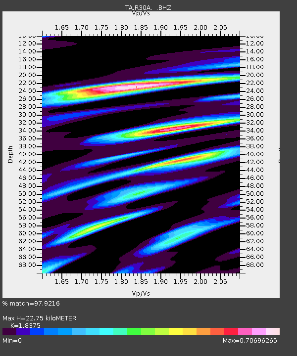
R30A Dighton, KS, USA - Earthquake Result Viewer

Earthquake location: Fox Islands, Aleutian Islands
Earthquake latitude/longitude: 52.9/-169.8
Earthquake time(UTC): 2010/07/18 (199) 05:56:44 GMT
Earthquake Depth: 14 km
Earthquake Magnitude: 6.3 MB, 6.7 MS, 6.6 MW, 6.6 MW
Earthquake Catalog/Contributor: WHDF/NEIC
Network: TA USArray Transportable Network (new EarthScope stations)
Station: R30A Dighton, KS, USA
Lat/Lon: 38.28 N/100.28 W
Elevation: 776 m
Distance: 48.9 deg
Az: 78.093 deg
Baz: 311.094 deg
Ray Param: 0.06903571
Estimated Moho Depth: 22.75 km
Estimated Crust Vp/Vs: 1.84
Assumed Crust Vp: 6.483 km/s
Estimated Crust Vs: 3.528 km/s
Estimated Crust Poisson's Ratio: 0.29
Radial Match: 97.9216 %
Radial Bump: 296
Transverse Match: 89.4364 %
Transverse Bump: 400
SOD ConfigId: 319893
Insert Time: 2011-01-05 05:53:07.082 +0000
GWidth: 2.5
Max Bumps: 400
Tol: 0.001

Signal To Noise

ChannelStoNSTALTA
TA:R30A: :BHZ:20100718T06:04:59.375007Z45.716574.8170646E-61.0536802E-7
TA:R30A: :BHN:20100718T06:04:59.375007Z14.3005651.7352226E-61.2133944E-7
TA:R30A: :BHE:20100718T06:04:59.375007Z22.4989382.021672E-68.985632E-8
Arrivals
Ps3.1 SECOND
PpPs9.4 SECOND
PsPs/PpSs13 SECOND