You are here: Home > Network List > US - United States National Seismic Network Stations List
> Station MSO Missoula, Montana, USA > Earthquake Result Viewer
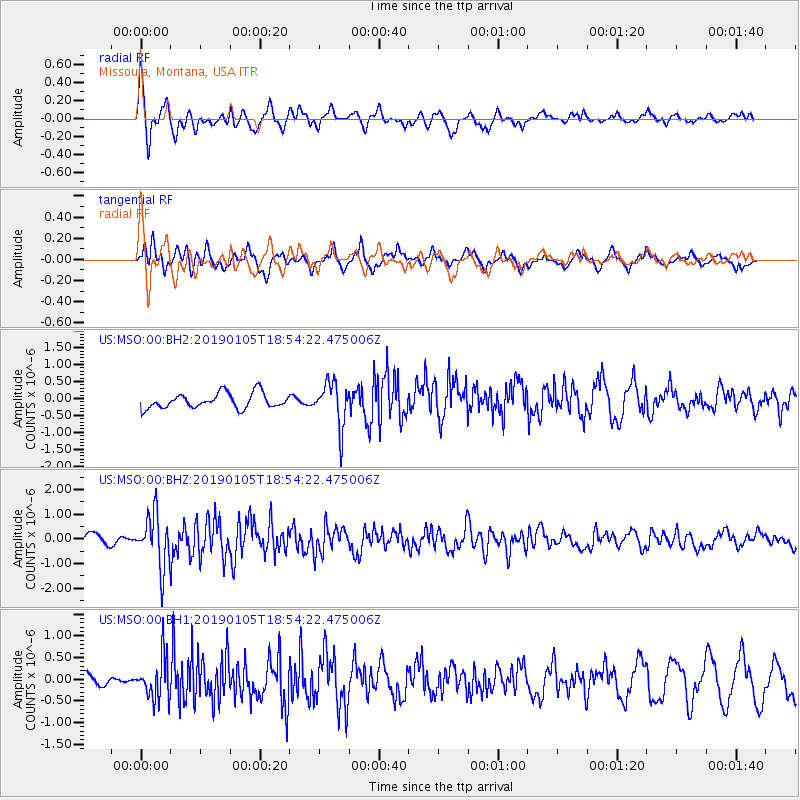
MSO Missoula, Montana, USA - Earthquake Result Viewer
*The percent match for this event was below the threshold and hence no stack was calculated.
| Earthquake location: |
Andreanof Islands, Aleutian Is. |
| Earthquake latitude/longitude: |
51.0/-178.2 |
| Earthquake time(UTC): |
2019/01/05 (005) 18:47:11 GMT |
| Earthquake Depth: |
35 km |
| Earthquake Magnitude: |
6.0 Mi |
| Earthquake Catalog/Contributor: |
NEIC PDE/at |
|
| Network: |
US United States National Seismic Network |
| Station: |
MSO Missoula, Montana, USA |
| Lat/Lon: |
46.83 N/113.94 W |
| Elevation: |
1264 m |
|
| Distance: |
41.3 deg |
| Az: |
69.699 deg |
| Baz: |
300.291 deg |
| Ray Param: |
$rayparam |
*The percent match for this event was below the threshold and hence was not used in the summary stack. |
|
| Radial Match: |
74.37626 % |
| Radial Bump: |
400 |
| Transverse Match: |
66.913414 % |
| Transverse Bump: |
400 |
| SOD ConfigId: |
3201911 |
| Insert Time: |
2019-01-19 19:03:10.043 +0000 |
| GWidth: |
2.5 |
| Max Bumps: |
400 |
| Tol: |
0.001 |
|
Signal To Noise
| Channel | StoN | STA | LTA |
| US:MSO:00:BHZ:20190105T18:54:22.475006Z | 5.208035 | 1.0456641E-6 | 2.00779E-7 |
| US:MSO:00:BH1:20190105T18:54:22.475006Z | 1.4453877 | 4.740889E-7 | 3.280012E-7 |
| US:MSO:00:BH2:20190105T18:54:22.475006Z | 2.8518753 | 6.38598E-7 | 2.2392214E-7 |
| Arrivals |
| Ps | |
| PpPs | |
| PsPs/PpSs | |


