You are here: Home > Network List > IU - Global Seismograph Network (GSN - IRIS/USGS) Stations List
> Station PMG Port Moresby, New Guinea > Earthquake Result Viewer
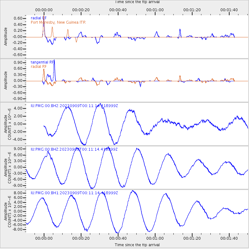
PMG Port Moresby, New Guinea - Earthquake Result Viewer
*The percent match for this event was below the threshold and hence no stack was calculated.
| Earthquake location: |
Bali Sea |
| Earthquake latitude/longitude: |
-6.8/116.6 |
| Earthquake time(UTC): |
2023/09/09 (252) 00:06:14 GMT |
| Earthquake Depth: |
509 km |
| Earthquake Magnitude: |
5.6 mb |
| Earthquake Catalog/Contributor: |
NEIC PDE/us |
|
| Network: |
IU Global Seismograph Network (GSN - IRIS/USGS) |
| Station: |
PMG Port Moresby, New Guinea |
| Lat/Lon: |
9.40 S/147.16 E |
| Elevation: |
90 m |
|
| Distance: |
30.4 deg |
| Az: |
96.933 deg |
| Baz: |
272.539 deg |
| Ray Param: |
$rayparam |
*The percent match for this event was below the threshold and hence was not used in the summary stack. |
|
| Radial Match: |
74.68184 % |
| Radial Bump: |
400 |
| Transverse Match: |
97.86027 % |
| Transverse Bump: |
199 |
| SOD ConfigId: |
31937991 |
| Insert Time: |
2023-09-23 00:11:57.062 +0000 |
| GWidth: |
2.5 |
| Max Bumps: |
400 |
| Tol: |
0.001 |
|
Signal To Noise
| Channel | StoN | STA | LTA |
| IU:PMG:00:BHZ:20230909T00:11:14.418999Z | 2.012198 | 5.75764E-6 | 2.8613683E-6 |
| IU:PMG:00:BH1:20230909T00:11:14.418999Z | 1.4306217 | 4.1806816E-6 | 2.922283E-6 |
| IU:PMG:00:BH2:20230909T00:11:14.418999Z | 1.5095341 | 4.5274337E-6 | 2.999226E-6 |
| Arrivals |
| Ps | |
| PpPs | |
| PsPs/PpSs | |


