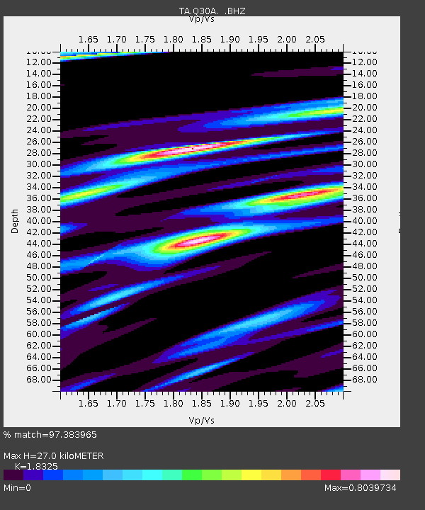
Q30A Quinter, KS, USA - Earthquake Result Viewer

Earthquake location: Fox Islands, Aleutian Islands
Earthquake latitude/longitude: 52.9/-169.8
Earthquake time(UTC): 2010/07/18 (199) 05:56:44 GMT
Earthquake Depth: 14 km
Earthquake Magnitude: 6.3 MB, 6.7 MS, 6.6 MW, 6.6 MW
Earthquake Catalog/Contributor: WHDF/NEIC
Network: TA USArray Transportable Network (new EarthScope stations)
Station: Q30A Quinter, KS, USA
Lat/Lon: 38.98 N/100.22 W
Elevation: 797 m
Distance: 48.5 deg
Az: 77.359 deg
Baz: 310.644 deg
Ray Param: 0.0693162
Estimated Moho Depth: 27.0 km
Estimated Crust Vp/Vs: 1.83
Assumed Crust Vp: 6.483 km/s
Estimated Crust Vs: 3.538 km/s
Estimated Crust Poisson's Ratio: 0.29
Radial Match: 97.383965 %
Radial Bump: 266
Transverse Match: 90.52992 %
Transverse Bump: 400
SOD ConfigId: 319893
Insert Time: 2011-01-05 05:53:54.094 +0000
GWidth: 2.5
Max Bumps: 400
Tol: 0.001

Signal To Noise

ChannelStoNSTALTA
TA:Q30A: :BHZ:20100718T06:04:56.150001Z31.8354054.1568564E-61.3057338E-7
TA:Q30A: :BHN:20100718T06:04:56.150001Z13.4004891.9280928E-61.4388227E-7
TA:Q30A: :BHE:20100718T06:04:56.150001Z18.8500211.957369E-61.038391E-7
Arrivals
Ps3.7 SECOND
PpPs11 SECOND
PsPs/PpSs15 SECOND