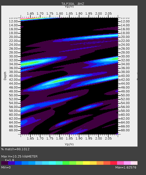
P30A Selden, KS, USA - Earthquake Result Viewer
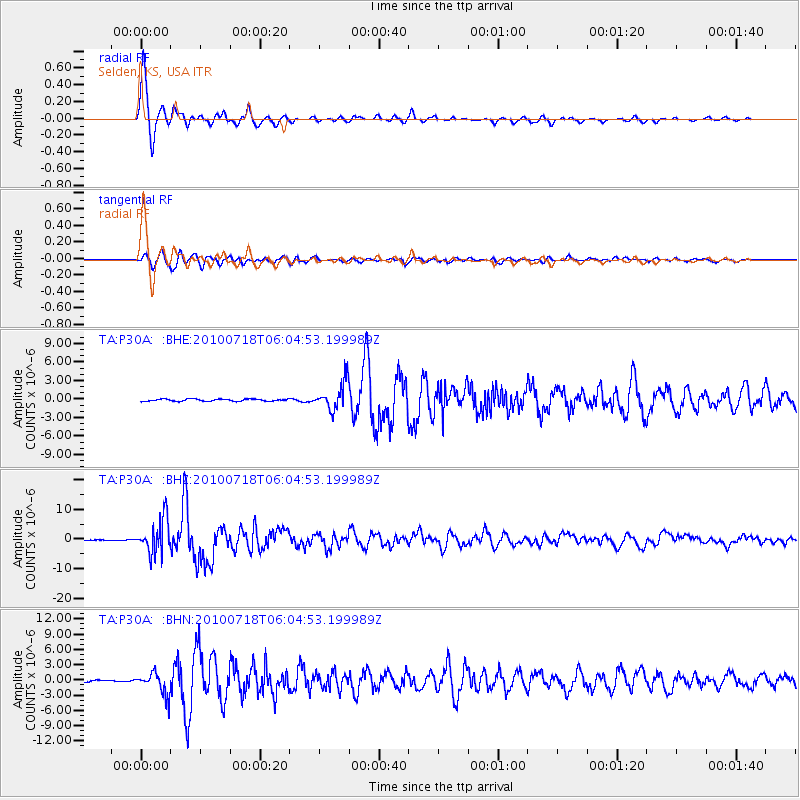
Earthquake location: Fox Islands, Aleutian Islands
Earthquake latitude/longitude: 52.9/-169.8
Earthquake time(UTC): 2010/07/18 (199) 05:56:44 GMT
Earthquake Depth: 14 km
Earthquake Magnitude: 6.3 MB, 6.7 MS, 6.6 MW, 6.6 MW
Earthquake Catalog/Contributor: WHDF/NEIC
Network: TA USArray Transportable Network (new EarthScope stations)
Station: P30A Selden, KS, USA
Lat/Lon: 39.54 N/100.25 W
Elevation: 788 m
Distance: 48.1 deg
Az: 76.799 deg
Baz: 310.256 deg
Ray Param: 0.06955885
Estimated Moho Depth: 10.25 km
Estimated Crust Vp/Vs: 1.60
Assumed Crust Vp: 6.483 km/s
Estimated Crust Vs: 4.052 km/s
Estimated Crust Poisson's Ratio: 0.18
Radial Match: 98.1012 %
Radial Bump: 304
Transverse Match: 93.07421 %
Transverse Bump: 400
SOD ConfigId: 319893
Insert Time: 2011-01-05 05:54:01.934 +0000
GWidth: 2.5
Max Bumps: 400
Tol: 0.001

Signal To Noise

ChannelStoNSTALTA
TA:P30A: :BHZ:20100718T06:04:53.199989Z70.573645.824477E-68.253049E-8
TA:P30A: :BHN:20100718T06:04:53.199989Z12.0762032.184062E-61.8085669E-7
TA:P30A: :BHE:20100718T06:04:53.199989Z12.8852232.195882E-61.7041862E-7
Arrivals
Ps1.0 SECOND
PpPs3.8 SECOND
PsPs/PpSs4.9 SECOND