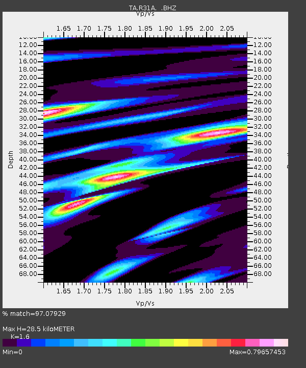
R31A Burdett, KS, USA - Earthquake Result Viewer
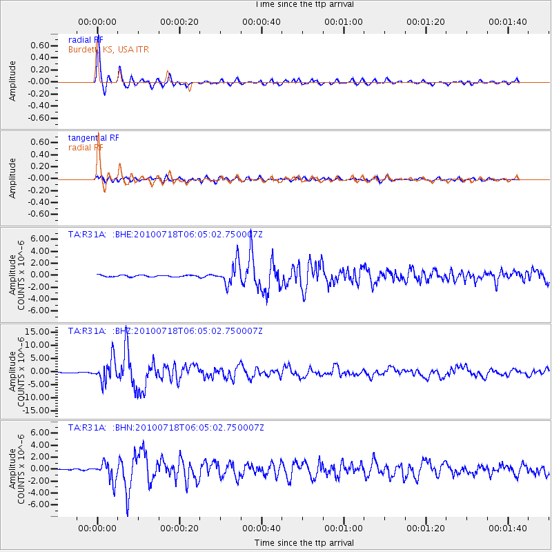
Earthquake location: Fox Islands, Aleutian Islands
Earthquake latitude/longitude: 52.9/-169.8
Earthquake time(UTC): 2010/07/18 (199) 05:56:44 GMT
Earthquake Depth: 14 km
Earthquake Magnitude: 6.3 MB, 6.7 MS, 6.6 MW, 6.6 MW
Earthquake Catalog/Contributor: WHDF/NEIC
Network: TA USArray Transportable Network (new EarthScope stations)
Station: R31A Burdett, KS, USA
Lat/Lon: 38.29 N/99.53 W
Elevation: 667 m
Distance: 49.4 deg
Az: 77.576 deg
Baz: 311.218 deg
Ray Param: 0.06874518
Estimated Moho Depth: 28.5 km
Estimated Crust Vp/Vs: 1.60
Assumed Crust Vp: 6.483 km/s
Estimated Crust Vs: 4.052 km/s
Estimated Crust Poisson's Ratio: 0.18
Radial Match: 97.07929 %
Radial Bump: 307
Transverse Match: 80.0103 %
Transverse Bump: 400
SOD ConfigId: 319893
Insert Time: 2011-01-05 05:54:05.005 +0000
GWidth: 2.5
Max Bumps: 400
Tol: 0.001

Signal To Noise

ChannelStoNSTALTA
TA:R31A: :BHZ:20100718T06:05:02.750007Z33.670974.4276785E-61.314984E-7
TA:R31A: :BHN:20100718T06:05:02.750007Z9.0831991.5811864E-61.7407815E-7
TA:R31A: :BHE:20100718T06:05:02.750007Z14.5109421.9172714E-61.321259E-7
Arrivals
Ps2.8 SECOND
PpPs11 SECOND
PsPs/PpSs14 SECOND