You are here: Home > Network List > TA - USArray Transportable Network (new EarthScope stations) Stations List
> Station M30A Dale-Ortello Valley, Anselmo, NE, USA > Earthquake Result Viewer
M30A Dale-Ortello Valley, Anselmo, NE, USA - Earthquake Result Viewer
| Earthquake location: |
Fox Islands, Aleutian Islands |
| Earthquake latitude/longitude: |
52.9/-169.8 |
| Earthquake time(UTC): |
2010/07/18 (199) 05:56:44 GMT |
| Earthquake Depth: |
14 km |
| Earthquake Magnitude: |
6.3 MB, 6.7 MS, 6.6 MW, 6.6 MW |
| Earthquake Catalog/Contributor: |
WHDF/NEIC |
|
| Network: |
TA USArray Transportable Network (new EarthScope stations) |
| Station: |
M30A Dale-Ortello Valley, Anselmo, NE, USA |
| Lat/Lon: |
41.54 N/99.87 W |
| Elevation: |
853 m |
|
| Distance: |
47.1 deg |
| Az: |
74.475 deg |
| Baz: |
308.93 deg |
| Ray Param: |
0.07023137 |
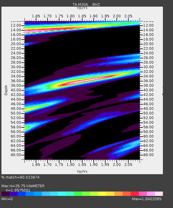
| Estimated Moho Depth: |
35.75 km |
| Estimated Crust Vp/Vs: |
1.86 |
| Assumed Crust Vp: |
6.53 km/s |
| Estimated Crust Vs: |
3.516 km/s |
| Estimated Crust Poisson's Ratio: |
0.30 |
|
| Radial Match: |
90.023674 % |
| Radial Bump: |
368 |
| Transverse Match: |
75.82828 % |
| Transverse Bump: |
400 |
| SOD ConfigId: |
319893 |
| Insert Time: |
2011-01-05 05:54:16.761 +0000 |
| GWidth: |
2.5 |
| Max Bumps: |
400 |
| Tol: |
0.001 |
|
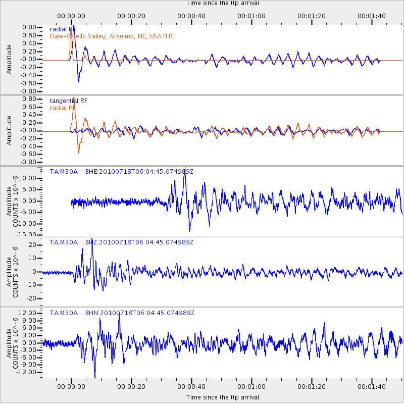
Signal To Noise
| Channel | StoN | STA | LTA |
| TA:M30A: :BHZ:20100718T06:04:45.074989Z | 13.380954 | 5.2348205E-6 | 3.9121431E-7 |
| TA:M30A: :BHN:20100718T06:04:45.074989Z | 2.6763759 | 2.4953965E-6 | 9.323789E-7 |
| TA:M30A: :BHE:20100718T06:04:45.074989Z | 3.423046 | 2.9613252E-6 | 8.6511403E-7 |
| Arrivals |
| Ps | 5.0 SECOND |
| PpPs | 15 SECOND |
| PsPs/PpSs | 20 SECOND |


