You are here: Home > Network List > TA - USArray Transportable Network (new EarthScope stations) Stations List
> Station L29A Maesberg Ranch, Thedford, NE, USA > Earthquake Result Viewer
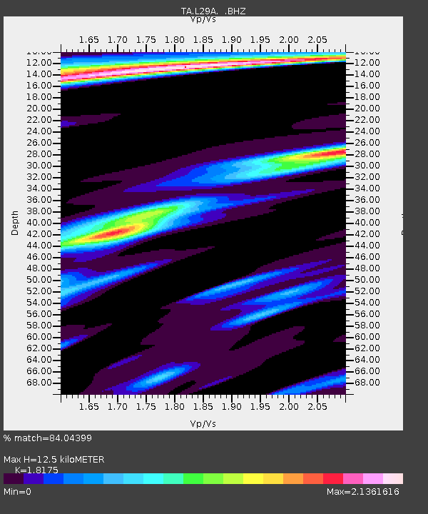
L29A Maesberg Ranch, Thedford, NE, USA - Earthquake Result Viewer
| Earthquake location: |
Fox Islands, Aleutian Islands |
| Earthquake latitude/longitude: |
52.9/-169.8 |
| Earthquake time(UTC): |
2010/07/18 (199) 05:56:44 GMT |
| Earthquake Depth: |
14 km |
| Earthquake Magnitude: |
6.3 MB, 6.7 MS, 6.6 MW, 6.6 MW |
| Earthquake Catalog/Contributor: |
WHDF/NEIC |
|
| Network: |
TA USArray Transportable Network (new EarthScope stations) |
| Station: |
L29A Maesberg Ranch, Thedford, NE, USA |
| Lat/Lon: |
42.06 N/100.48 W |
| Elevation: |
901 m |
|
| Distance: |
46.4 deg |
| Az: |
74.299 deg |
| Baz: |
308.407 deg |
| Ray Param: |
0.07067214 |
| Estimated Moho Depth: |
12.5 km |
| Estimated Crust Vp/Vs: |
1.82 |
| Assumed Crust Vp: |
6.483 km/s |
| Estimated Crust Vs: |
3.567 km/s |
| Estimated Crust Poisson's Ratio: |
0.28 |
|
| Radial Match: |
84.04399 % |
| Radial Bump: |
273 |
| Transverse Match: |
66.127594 % |
| Transverse Bump: |
400 |
| SOD ConfigId: |
319893 |
| Insert Time: |
2011-01-05 05:55:08.937 +0000 |
| GWidth: |
2.5 |
| Max Bumps: |
400 |
| Tol: |
0.001 |
|

Signal To Noise
| Channel | StoN | STA | LTA |
| TA:L29A: :BHZ:20100718T06:04:39.725013Z | 18.798975 | 3.3151218E-6 | 1.7634589E-7 |
| TA:L29A: :BHN:20100718T06:04:39.725013Z | 2.0068593 | 1.4049984E-6 | 7.0009816E-7 |
| TA:L29A: :BHE:20100718T06:04:39.725013Z | 4.4623504 | 1.8885092E-6 | 4.2320954E-7 |
| Arrivals |
| Ps | 1.7 SECOND |
| PpPs | 5.1 SECOND |
| PsPs/PpSs | 6.8 SECOND |


