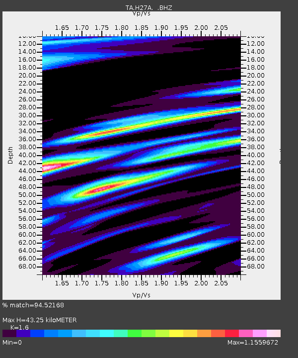
H27A Howes, SD, USA - Earthquake Result Viewer

Earthquake location: Fox Islands, Aleutian Islands
Earthquake latitude/longitude: 52.9/-169.8
Earthquake time(UTC): 2010/07/18 (199) 05:56:44 GMT
Earthquake Depth: 14 km
Earthquake Magnitude: 6.3 MB, 6.7 MS, 6.6 MW, 6.6 MW
Earthquake Catalog/Contributor: WHDF/NEIC
Network: TA USArray Transportable Network (new EarthScope stations)
Station: H27A Howes, SD, USA
Lat/Lon: 44.63 N/102.08 W
Elevation: 748 m
Distance: 43.9 deg
Az: 72.408 deg
Baz: 305.979 deg
Ray Param: 0.07224395
Estimated Moho Depth: 43.25 km
Estimated Crust Vp/Vs: 1.60
Assumed Crust Vp: 6.242 km/s
Estimated Crust Vs: 3.901 km/s
Estimated Crust Poisson's Ratio: 0.18
Radial Match: 94.52168 %
Radial Bump: 363
Transverse Match: 79.005905 %
Transverse Bump: 400
SOD ConfigId: 319893
Insert Time: 2011-01-05 05:55:26.862 +0000
GWidth: 2.5
Max Bumps: 400
Tol: 0.001

Signal To Noise

ChannelStoNSTALTA
TA:H27A: :BHZ:20100718T06:04:20.049995Z12.83643152.65105E-62.0652547E-7
TA:H27A: :BHN:20100718T06:04:20.049995Z6.13117741.3098088E-62.1363088E-7
TA:H27A: :BHE:20100718T06:04:20.049995Z4.40886261.7074035E-63.872662E-7
Arrivals
Ps4.5 SECOND
PpPs17 SECOND
PsPs/PpSs21 SECOND