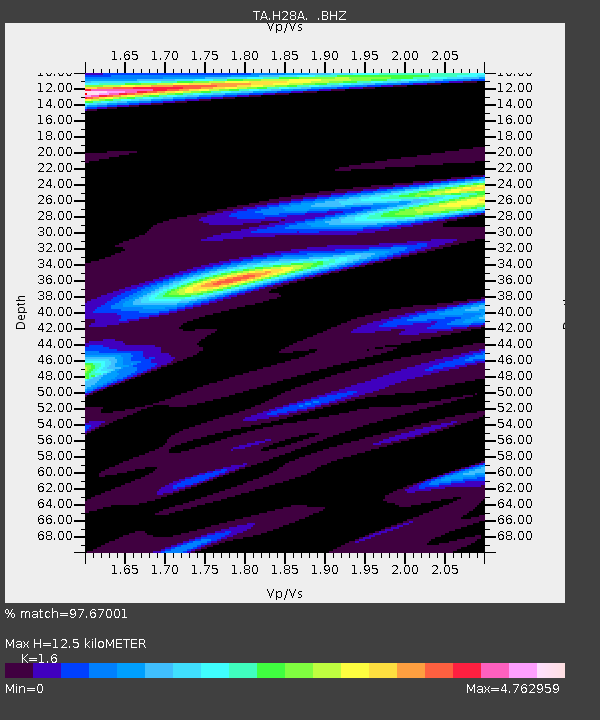
H28A Mission Ridge, SD, USA - Earthquake Result Viewer
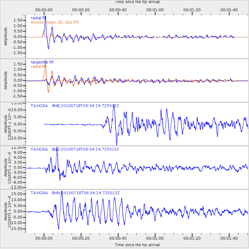
Earthquake location: Fox Islands, Aleutian Islands
Earthquake latitude/longitude: 52.9/-169.8
Earthquake time(UTC): 2010/07/18 (199) 05:56:44 GMT
Earthquake Depth: 14 km
Earthquake Magnitude: 6.3 MB, 6.7 MS, 6.6 MW, 6.6 MW
Earthquake Catalog/Contributor: WHDF/NEIC
Network: TA USArray Transportable Network (new EarthScope stations)
Station: H28A Mission Ridge, SD, USA
Lat/Lon: 44.68 N/101.02 W
Elevation: 642 m
Distance: 44.5 deg
Az: 71.722 deg
Baz: 306.227 deg
Ray Param: 0.07188089
Estimated Moho Depth: 12.5 km
Estimated Crust Vp/Vs: 1.60
Assumed Crust Vp: 6.53 km/s
Estimated Crust Vs: 4.082 km/s
Estimated Crust Poisson's Ratio: 0.18
Radial Match: 97.67001 %
Radial Bump: 342
Transverse Match: 95.40995 %
Transverse Bump: 400
SOD ConfigId: 319893
Insert Time: 2011-01-05 05:55:39.144 +0000
GWidth: 2.5
Max Bumps: 400
Tol: 0.001

Signal To Noise

ChannelStoNSTALTA
TA:H28A: :BHZ:20100718T06:04:24.725013Z47.5475042.1992846E-64.625447E-8
TA:H28A: :BHN:20100718T06:04:24.725013Z5.15081.7325723E-63.3636954E-7
TA:H28A: :BHE:20100718T06:04:24.725013Z11.2415692.1073458E-61.8746012E-7
Arrivals
Ps1.2 SECOND
PpPs4.6 SECOND
PsPs/PpSs5.9 SECOND