H25A Fruitdale, SD, USA - Earthquake Result Viewer
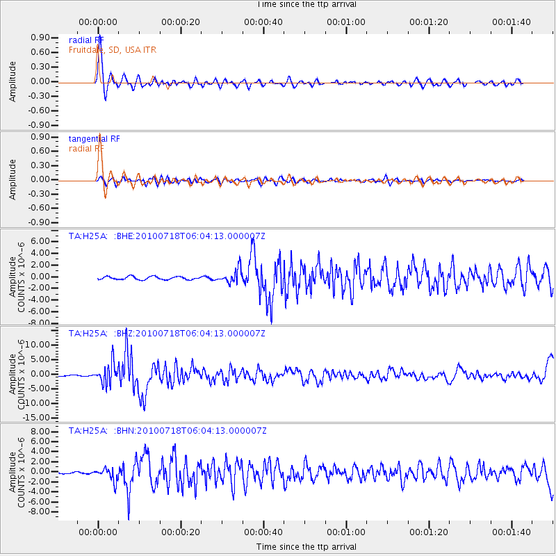
Earthquake location: Fox Islands, Aleutian Islands
Earthquake latitude/longitude: 52.9/-169.8
Earthquake time(UTC): 2010/07/18 (199) 05:56:44 GMT
Earthquake Depth: 14 km
Earthquake Magnitude: 6.3 MB, 6.7 MS, 6.6 MW, 6.6 MW
Earthquake Catalog/Contributor: WHDF/NEIC
Network: TA USArray Transportable Network (new EarthScope stations)
Station: H25A Fruitdale, SD, USA
Lat/Lon: 44.62 N/103.60 W
Elevation: 942 m
Distance: 43.0 deg
Az: 73.345 deg
Baz: 305.594 deg
Ray Param: 0.072808996
Estimated Moho Depth: 23.25 km
Estimated Crust Vp/Vs: 1.78
Assumed Crust Vp: 6.242 km/s
Estimated Crust Vs: 3.507 km/s
Estimated Crust Poisson's Ratio: 0.27
Radial Match: 91.76011 %
Radial Bump: 400
Transverse Match: 68.64746 %
Transverse Bump: 400
SOD ConfigId: 319893
Insert Time: 2011-01-05 05:55:56.279 +0000
GWidth: 2.5
Max Bumps: 400
Tol: 0.001

Signal To Noise

ChannelStoNSTALTA
TA:H25A: :BHZ:20100718T06:04:13.000007Z23.1998483.5730015E-61.540097E-7
TA:H25A: :BHN:20100718T06:04:13.000007Z6.28708461.3066362E-62.0782865E-7
TA:H25A: :BHE:20100718T06:04:13.000007Z4.73134951.2374577E-62.6154433E-7
Arrivals
Ps3.1 SECOND
PpPs9.7 SECOND
PsPs/PpSs13 SECOND