You are here: Home > Network List > TA - USArray Transportable Network (new EarthScope stations) Stations List
> Station J26A Sides Ranch, Smithwick, SD, USA > Earthquake Result Viewer
J26A Sides Ranch, Smithwick, SD, USA - Earthquake Result Viewer
| Earthquake location: |
Fox Islands, Aleutian Islands |
| Earthquake latitude/longitude: |
52.9/-169.8 |
| Earthquake time(UTC): |
2010/07/18 (199) 05:56:44 GMT |
| Earthquake Depth: |
14 km |
| Earthquake Magnitude: |
6.3 MB, 6.7 MS, 6.6 MW, 6.6 MW |
| Earthquake Catalog/Contributor: |
WHDF/NEIC |
|
| Network: |
TA USArray Transportable Network (new EarthScope stations) |
| Station: |
J26A Sides Ranch, Smithwick, SD, USA |
| Lat/Lon: |
43.31 N/103.08 W |
| Elevation: |
993 m |
|
| Distance: |
44.1 deg |
| Az: |
74.553 deg |
| Baz: |
306.832 deg |
| Ray Param: |
0.072115354 |
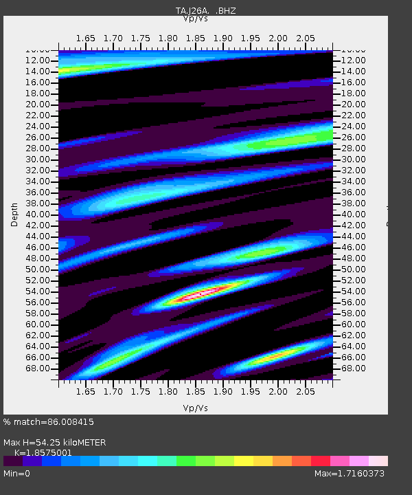
| Estimated Moho Depth: |
54.25 km |
| Estimated Crust Vp/Vs: |
1.86 |
| Assumed Crust Vp: |
6.483 km/s |
| Estimated Crust Vs: |
3.49 km/s |
| Estimated Crust Poisson's Ratio: |
0.30 |
|
| Radial Match: |
86.008415 % |
| Radial Bump: |
400 |
| Transverse Match: |
66.40616 % |
| Transverse Bump: |
400 |
| SOD ConfigId: |
319893 |
| Insert Time: |
2011-01-05 05:57:01.955 +0000 |
| GWidth: |
2.5 |
| Max Bumps: |
400 |
| Tol: |
0.001 |
|
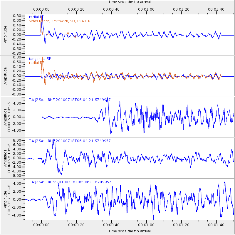
Signal To Noise
| Channel | StoN | STA | LTA |
| TA:J26A: :BHZ:20100718T06:04:21.674995Z | 20.333958 | 1.9781899E-6 | 9.728503E-8 |
| TA:J26A: :BHN:20100718T06:04:21.674995Z | 5.887282 | 9.272999E-7 | 1.57509E-7 |
| TA:J26A: :BHE:20100718T06:04:21.674995Z | 7.0212913 | 1.0464945E-6 | 1.4904587E-7 |
| Arrivals |
| Ps | 7.6 SECOND |
| PpPs | 22 SECOND |
| PsPs/PpSs | 30 SECOND |


