You are here: Home > Network List > TA - USArray Transportable Network (new EarthScope stations) Stations List
> Station B27A Peters Farms, Glenburn, ND, USA > Earthquake Result Viewer
B27A Peters Farms, Glenburn, ND, USA - Earthquake Result Viewer
| Earthquake location: |
Fox Islands, Aleutian Islands |
| Earthquake latitude/longitude: |
52.9/-169.8 |
| Earthquake time(UTC): |
2010/07/18 (199) 05:56:44 GMT |
| Earthquake Depth: |
14 km |
| Earthquake Magnitude: |
6.3 MB, 6.7 MS, 6.6 MW, 6.6 MW |
| Earthquake Catalog/Contributor: |
WHDF/NEIC |
|
| Network: |
TA USArray Transportable Network (new EarthScope stations) |
| Station: |
B27A Peters Farms, Glenburn, ND, USA |
| Lat/Lon: |
48.40 N/101.26 W |
| Elevation: |
492 m |
|
| Distance: |
42.2 deg |
| Az: |
67.383 deg |
| Baz: |
302.897 deg |
| Ray Param: |
0.073287085 |
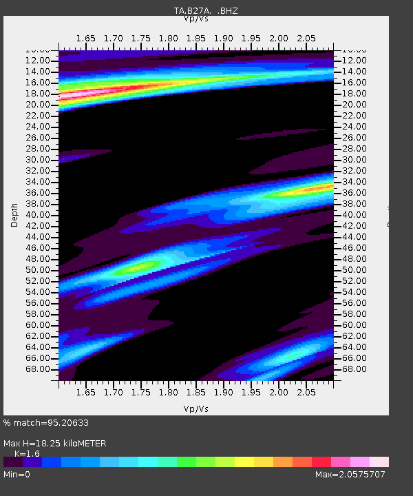
| Estimated Moho Depth: |
18.25 km |
| Estimated Crust Vp/Vs: |
1.60 |
| Assumed Crust Vp: |
6.438 km/s |
| Estimated Crust Vs: |
4.023 km/s |
| Estimated Crust Poisson's Ratio: |
0.18 |
|
| Radial Match: |
95.20633 % |
| Radial Bump: |
284 |
| Transverse Match: |
87.998245 % |
| Transverse Bump: |
400 |
| SOD ConfigId: |
319893 |
| Insert Time: |
2011-01-05 05:57:20.864 +0000 |
| GWidth: |
2.5 |
| Max Bumps: |
400 |
| Tol: |
0.001 |
|

Signal To Noise
| Channel | StoN | STA | LTA |
| TA:B27A: :BHZ:20100718T06:04:06.549995Z | 39.055058 | 3.907267E-6 | 1.0004509E-7 |
| TA:B27A: :BHN:20100718T06:04:06.549995Z | 1.5603449 | 9.390535E-7 | 6.018243E-7 |
| TA:B27A: :BHE:20100718T06:04:06.549995Z | 5.9276752 | 1.7423099E-6 | 2.9392805E-7 |
| Arrivals |
| Ps | 1.8 SECOND |
| PpPs | 6.8 SECOND |
| PsPs/PpSs | 8.7 SECOND |


