You are here: Home > Network List > TA - USArray Transportable Network (new EarthScope stations) Stations List
> Station C30A Mose, Pekin, ND, USA > Earthquake Result Viewer
C30A Mose, Pekin, ND, USA - Earthquake Result Viewer
| Earthquake location: |
Fox Islands, Aleutian Islands |
| Earthquake latitude/longitude: |
52.9/-169.8 |
| Earthquake time(UTC): |
2010/07/18 (199) 05:56:44 GMT |
| Earthquake Depth: |
14 km |
| Earthquake Magnitude: |
6.3 MB, 6.7 MS, 6.6 MW, 6.6 MW |
| Earthquake Catalog/Contributor: |
WHDF/NEIC |
|
| Network: |
TA USArray Transportable Network (new EarthScope stations) |
| Station: |
C30A Mose, Pekin, ND, USA |
| Lat/Lon: |
47.70 N/98.48 W |
| Elevation: |
480 m |
|
| Distance: |
44.2 deg |
| Az: |
66.724 deg |
| Baz: |
304.48 deg |
| Ray Param: |
0.072072625 |
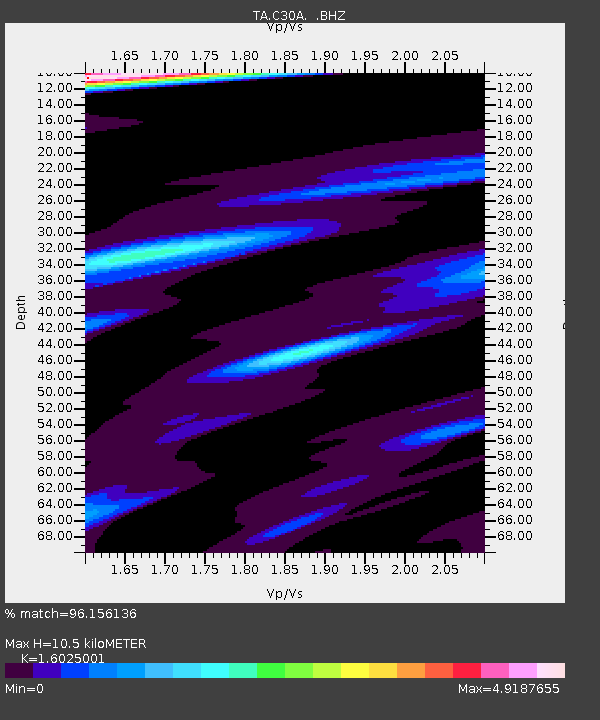
| Estimated Moho Depth: |
10.5 km |
| Estimated Crust Vp/Vs: |
1.60 |
| Assumed Crust Vp: |
6.53 km/s |
| Estimated Crust Vs: |
4.075 km/s |
| Estimated Crust Poisson's Ratio: |
0.18 |
|
| Radial Match: |
96.156136 % |
| Radial Bump: |
353 |
| Transverse Match: |
85.31862 % |
| Transverse Bump: |
400 |
| SOD ConfigId: |
319893 |
| Insert Time: |
2011-01-05 05:57:33.285 +0000 |
| GWidth: |
2.5 |
| Max Bumps: |
400 |
| Tol: |
0.001 |
|
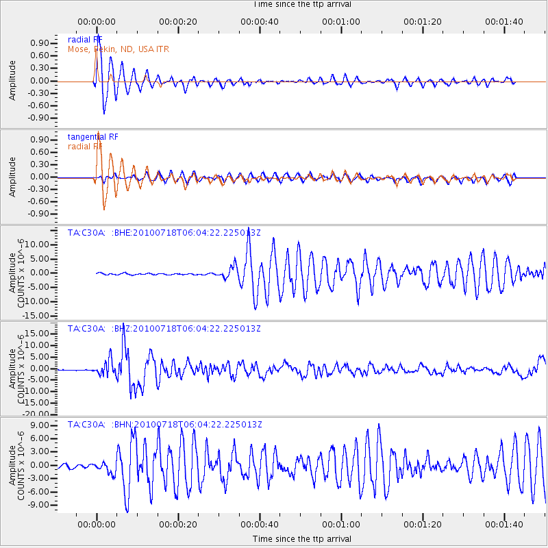
Signal To Noise
| Channel | StoN | STA | LTA |
| TA:C30A: :BHZ:20100718T06:04:22.225013Z | 21.189405 | 3.346552E-6 | 1.5793516E-7 |
| TA:C30A: :BHN:20100718T06:04:22.225013Z | 3.0153193 | 1.2503687E-6 | 4.1467206E-7 |
| TA:C30A: :BHE:20100718T06:04:22.225013Z | 8.048977 | 2.0438688E-6 | 2.5392902E-7 |
| Arrivals |
| Ps | 1.0 SECOND |
| PpPs | 3.9 SECOND |
| PsPs/PpSs | 4.9 SECOND |


