You are here: Home > Network List > AK - Alaska Regional Network Stations List
> Station C16K Lisburne Hills, AK, USA > Earthquake Result Viewer
C16K Lisburne Hills, AK, USA - Earthquake Result Viewer
| Earthquake location: |
Minahassa Peninsula, Sulawesi |
| Earthquake latitude/longitude: |
0.0/119.8 |
| Earthquake time(UTC): |
2023/09/09 (252) 14:43:24 GMT |
| Earthquake Depth: |
9.9 km |
| Earthquake Magnitude: |
6.0 mww |
| Earthquake Catalog/Contributor: |
NEIC PDE/us |
|
| Network: |
AK Alaska Regional Network |
| Station: |
C16K Lisburne Hills, AK, USA |
| Lat/Lon: |
68.27 N/165.34 W |
| Elevation: |
102 m |
|
| Distance: |
84.4 deg |
| Az: |
21.17 deg |
| Baz: |
255.929 deg |
| Ray Param: |
0.04549657 |
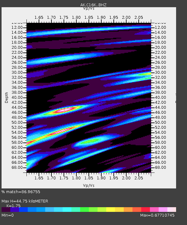
| Estimated Moho Depth: |
44.75 km |
| Estimated Crust Vp/Vs: |
1.75 |
| Assumed Crust Vp: |
5.906 km/s |
| Estimated Crust Vs: |
3.375 km/s |
| Estimated Crust Poisson's Ratio: |
0.26 |
|
| Radial Match: |
86.96755 % |
| Radial Bump: |
348 |
| Transverse Match: |
78.276955 % |
| Transverse Bump: |
400 |
| SOD ConfigId: |
31937991 |
| Insert Time: |
2023-09-23 14:45:08.155 +0000 |
| GWidth: |
2.5 |
| Max Bumps: |
400 |
| Tol: |
0.001 |
|

Signal To Noise
| Channel | StoN | STA | LTA |
| AK:C16K: :BHZ:20230909T14:55:25.600023Z | 5.247175 | 4.8562293E-7 | 9.2549406E-8 |
| AK:C16K: :BHN:20230909T14:55:25.600023Z | 0.6145521 | 9.882624E-8 | 1.6081019E-7 |
| AK:C16K: :BHE:20230909T14:55:25.600023Z | 1.4090536 | 1.8786623E-7 | 1.3332796E-7 |
| Arrivals |
| Ps | 5.8 SECOND |
| PpPs | 20 SECOND |
| PsPs/PpSs | 26 SECOND |


