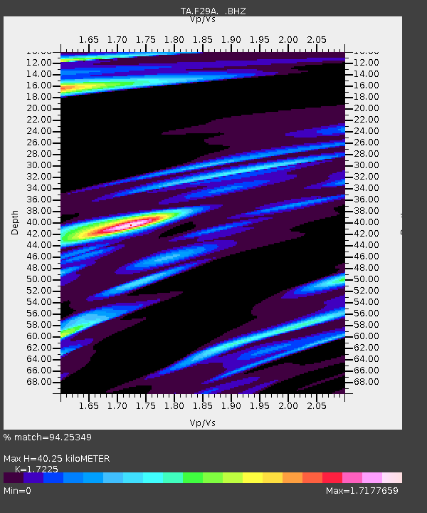
F29A Eureka, SD, USA - Earthquake Result Viewer
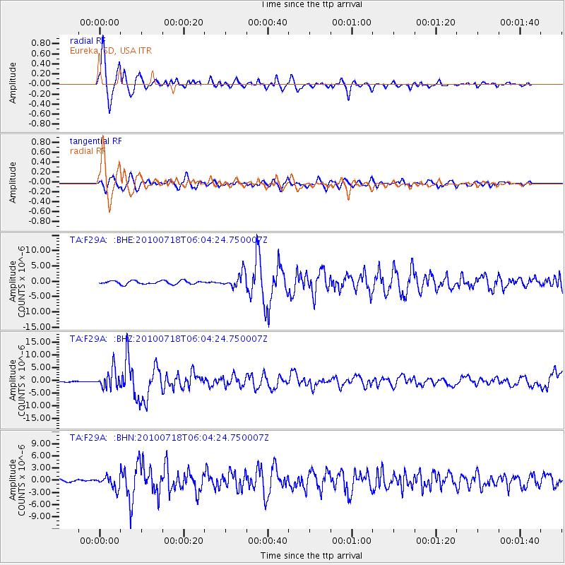
Earthquake location: Fox Islands, Aleutian Islands
Earthquake latitude/longitude: 52.9/-169.8
Earthquake time(UTC): 2010/07/18 (199) 05:56:44 GMT
Earthquake Depth: 14 km
Earthquake Magnitude: 6.3 MB, 6.7 MS, 6.6 MW, 6.6 MW
Earthquake Catalog/Contributor: WHDF/NEIC
Network: TA USArray Transportable Network (new EarthScope stations)
Station: F29A Eureka, SD, USA
Lat/Lon: 45.83 N/99.83 W
Elevation: 575 m
Distance: 44.5 deg
Az: 69.677 deg
Baz: 305.613 deg
Ray Param: 0.07187907
Estimated Moho Depth: 40.25 km
Estimated Crust Vp/Vs: 1.72
Assumed Crust Vp: 6.53 km/s
Estimated Crust Vs: 3.791 km/s
Estimated Crust Poisson's Ratio: 0.25
Radial Match: 94.25349 %
Radial Bump: 399
Transverse Match: 84.547745 %
Transverse Bump: 400
SOD ConfigId: 319893
Insert Time: 2011-01-05 05:58:33.716 +0000
GWidth: 2.5
Max Bumps: 400
Tol: 0.001

Signal To Noise

ChannelStoNSTALTA
TA:F29A: :BHZ:20100718T06:04:24.750007Z16.0250683.6515682E-62.27866E-7
TA:F29A: :BHN:20100718T06:04:24.750007Z3.80951021.4852226E-63.8987233E-7
TA:F29A: :BHE:20100718T06:04:24.750007Z4.4246822.4305782E-65.493227E-7
Arrivals
Ps4.8 SECOND
PpPs16 SECOND
PsPs/PpSs20 SECOND