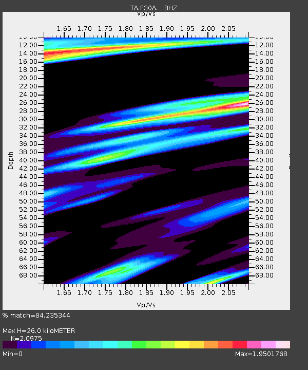
F30A Leola, SD, USA - Earthquake Result Viewer
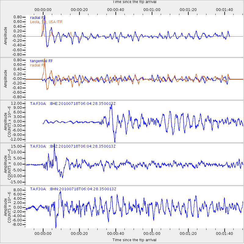
Earthquake location: Fox Islands, Aleutian Islands
Earthquake latitude/longitude: 52.9/-169.8
Earthquake time(UTC): 2010/07/18 (199) 05:56:44 GMT
Earthquake Depth: 14 km
Earthquake Magnitude: 6.3 MB, 6.7 MS, 6.6 MW, 6.6 MW
Earthquake Catalog/Contributor: WHDF/NEIC
Network: TA USArray Transportable Network (new EarthScope stations)
Station: F30A Leola, SD, USA
Lat/Lon: 45.84 N/99.03 W
Elevation: 601 m
Distance: 44.9 deg
Az: 69.209 deg
Baz: 305.854 deg
Ray Param: 0.07159829
Estimated Moho Depth: 26.0 km
Estimated Crust Vp/Vs: 2.10
Assumed Crust Vp: 6.53 km/s
Estimated Crust Vs: 3.113 km/s
Estimated Crust Poisson's Ratio: 0.35
Radial Match: 84.235344 %
Radial Bump: 400
Transverse Match: 75.05415 %
Transverse Bump: 400
SOD ConfigId: 319893
Insert Time: 2011-01-05 05:58:58.849 +0000
GWidth: 2.5
Max Bumps: 400
Tol: 0.001

Signal To Noise

ChannelStoNSTALTA
TA:F30A: :BHZ:20100718T06:04:28.350013Z13.1657922.8853128E-62.1915224E-7
TA:F30A: :BHN:20100718T06:04:28.350013Z2.91467481.2064689E-64.1392917E-7
TA:F30A: :BHE:20100718T06:04:28.350013Z3.36331651.5949552E-64.7422097E-7
Arrivals
Ps4.6 SECOND
PpPs12 SECOND
PsPs/PpSs16 SECOND