You are here: Home > Network List > TA - USArray Transportable Network (new EarthScope stations) Stations List
> Station N31A Bailey Ranch, Gibbon, NE, USA > Earthquake Result Viewer
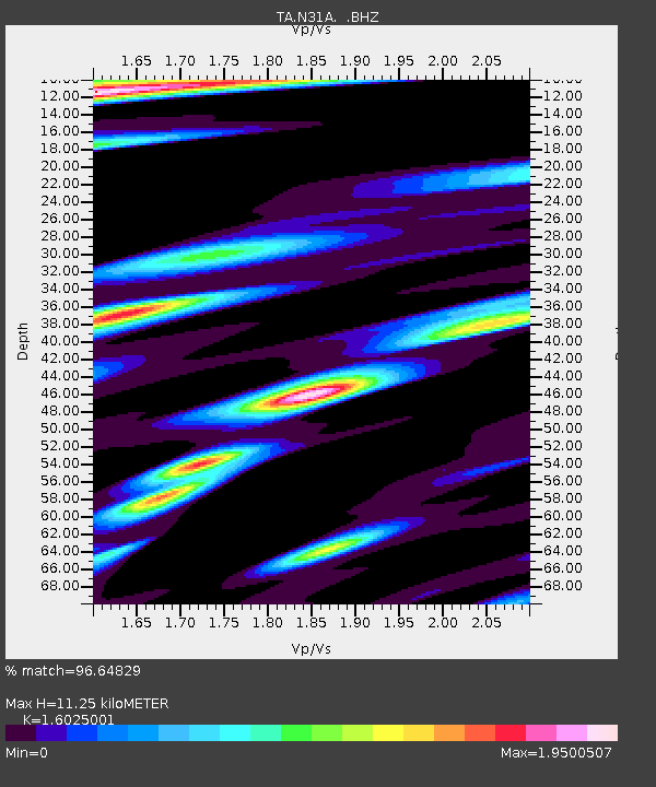
N31A Bailey Ranch, Gibbon, NE, USA - Earthquake Result Viewer
| Earthquake location: |
Fox Islands, Aleutian Islands |
| Earthquake latitude/longitude: |
52.9/-169.8 |
| Earthquake time(UTC): |
2010/07/18 (199) 05:56:44 GMT |
| Earthquake Depth: |
14 km |
| Earthquake Magnitude: |
6.3 MB, 6.7 MS, 6.6 MW, 6.6 MW |
| Earthquake Catalog/Contributor: |
WHDF/NEIC |
|
| Network: |
TA USArray Transportable Network (new EarthScope stations) |
| Station: |
N31A Bailey Ranch, Gibbon, NE, USA |
| Lat/Lon: |
40.82 N/98.95 W |
| Elevation: |
687 m |
|
| Distance: |
48.0 deg |
| Az: |
74.628 deg |
| Baz: |
309.636 deg |
| Ray Param: |
0.06959699 |
| Estimated Moho Depth: |
11.25 km |
| Estimated Crust Vp/Vs: |
1.60 |
| Assumed Crust Vp: |
6.53 km/s |
| Estimated Crust Vs: |
4.075 km/s |
| Estimated Crust Poisson's Ratio: |
0.18 |
|
| Radial Match: |
96.64829 % |
| Radial Bump: |
400 |
| Transverse Match: |
89.2997 % |
| Transverse Bump: |
400 |
| SOD ConfigId: |
319893 |
| Insert Time: |
2011-01-05 05:59:23.328 +0000 |
| GWidth: |
2.5 |
| Max Bumps: |
400 |
| Tol: |
0.001 |
|

Signal To Noise
| Channel | StoN | STA | LTA |
| TA:N31A: :BHZ:20100718T06:04:52.725013Z | 24.907684 | 4.8715856E-6 | 1.9558564E-7 |
| TA:N31A: :BHN:20100718T06:04:52.725013Z | 5.6819353 | 1.9714025E-6 | 3.469597E-7 |
| TA:N31A: :BHE:20100718T06:04:52.725013Z | 7.3307214 | 2.1798485E-6 | 2.9735799E-7 |
| Arrivals |
| Ps | 1.1 SECOND |
| PpPs | 4.2 SECOND |
| PsPs/PpSs | 5.3 SECOND |


