You are here: Home > Network List > GO - National Seismic Network of Georgia Stations List
> Station EMLK Emlikli, Georgia > Earthquake Result Viewer
EMLK Emlikli, Georgia - Earthquake Result Viewer
| Earthquake location: |
Minahassa Peninsula, Sulawesi |
| Earthquake latitude/longitude: |
0.0/119.8 |
| Earthquake time(UTC): |
2023/09/09 (252) 14:43:24 GMT |
| Earthquake Depth: |
9.9 km |
| Earthquake Magnitude: |
6.0 mww |
| Earthquake Catalog/Contributor: |
NEIC PDE/us |
|
| Network: |
GO National Seismic Network of Georgia |
| Station: |
EMLK Emlikli, Georgia |
| Lat/Lon: |
41.21 N/43.95 E |
| Elevation: |
2939 m |
|
| Distance: |
79.3 deg |
| Az: |
311.901 deg |
| Baz: |
99.413 deg |
| Ray Param: |
0.049030565 |
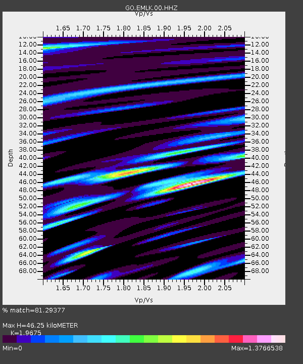
| Estimated Moho Depth: |
46.25 km |
| Estimated Crust Vp/Vs: |
1.97 |
| Assumed Crust Vp: |
6.419 km/s |
| Estimated Crust Vs: |
3.263 km/s |
| Estimated Crust Poisson's Ratio: |
0.33 |
|
| Radial Match: |
81.29377 % |
| Radial Bump: |
400 |
| Transverse Match: |
88.33394 % |
| Transverse Bump: |
400 |
| SOD ConfigId: |
31937991 |
| Insert Time: |
2023-09-23 14:51:22.249 +0000 |
| GWidth: |
2.5 |
| Max Bumps: |
400 |
| Tol: |
0.001 |
|

Signal To Noise
| Channel | StoN | STA | LTA |
| GO:EMLK:00:HHZ:20230909T14:54:58.970019Z | 8.038809 | 7.330164E-7 | 9.11847E-8 |
| GO:EMLK:00:HHN:20230909T14:54:58.970019Z | 0.8501683 | 1.1188018E-7 | 1.3159769E-7 |
| GO:EMLK:00:HHE:20230909T14:54:58.970019Z | 1.4478209 | 2.6186078E-7 | 1.8086544E-7 |
| Arrivals |
| Ps | 7.2 SECOND |
| PpPs | 21 SECOND |
| PsPs/PpSs | 28 SECOND |


