You are here: Home > Network List > GO - National Seismic Network of Georgia Stations List
> Station MTAG MTAG,Georgia > Earthquake Result Viewer
MTAG MTAG,Georgia - Earthquake Result Viewer
| Earthquake location: |
Minahassa Peninsula, Sulawesi |
| Earthquake latitude/longitude: |
0.0/119.8 |
| Earthquake time(UTC): |
2023/09/09 (252) 14:43:24 GMT |
| Earthquake Depth: |
9.9 km |
| Earthquake Magnitude: |
6.0 mww |
| Earthquake Catalog/Contributor: |
NEIC PDE/us |
|
| Network: |
GO National Seismic Network of Georgia |
| Station: |
MTAG MTAG,Georgia |
| Lat/Lon: |
42.09 N/45.16 E |
| Elevation: |
728 m |
|
| Distance: |
78.6 deg |
| Az: |
312.943 deg |
| Baz: |
100.414 deg |
| Ray Param: |
0.049530234 |
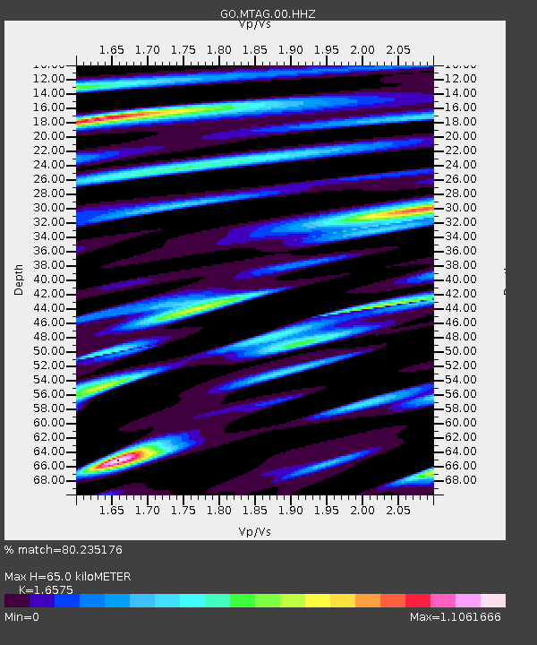
| Estimated Moho Depth: |
65.0 km |
| Estimated Crust Vp/Vs: |
1.66 |
| Assumed Crust Vp: |
6.142 km/s |
| Estimated Crust Vs: |
3.706 km/s |
| Estimated Crust Poisson's Ratio: |
0.21 |
|
| Radial Match: |
80.235176 % |
| Radial Bump: |
400 |
| Transverse Match: |
71.68204 % |
| Transverse Bump: |
400 |
| SOD ConfigId: |
31937991 |
| Insert Time: |
2023-09-23 14:51:28.784 +0000 |
| GWidth: |
2.5 |
| Max Bumps: |
400 |
| Tol: |
0.001 |
|

Signal To Noise
| Channel | StoN | STA | LTA |
| GO:MTAG:00:HHZ:20230909T14:54:54.910021Z | 5.412557 | 3.676555E-7 | 6.792639E-8 |
| GO:MTAG:00:HHN:20230909T14:54:54.910021Z | 2.9632874 | 1.2701595E-7 | 4.2863192E-8 |
| GO:MTAG:00:HHE:20230909T14:54:54.910021Z | 3.2444127 | 1.7753564E-7 | 5.4720427E-8 |
| Arrivals |
| Ps | 7.2 SECOND |
| PpPs | 27 SECOND |
| PsPs/PpSs | 34 SECOND |


