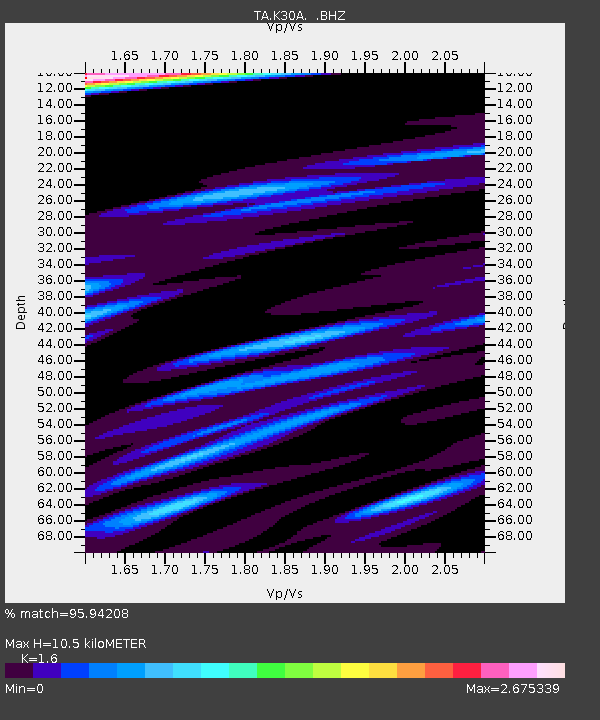
K30A Basset, NE, USA - Earthquake Result Viewer

Earthquake location: Fox Islands, Aleutian Islands
Earthquake latitude/longitude: 52.9/-169.8
Earthquake time(UTC): 2010/07/18 (199) 05:56:44 GMT
Earthquake Depth: 14 km
Earthquake Magnitude: 6.3 MB, 6.7 MS, 6.6 MW, 6.6 MW
Earthquake Catalog/Contributor: WHDF/NEIC
Network: TA USArray Transportable Network (new EarthScope stations)
Station: K30A Basset, NE, USA
Lat/Lon: 42.67 N/99.61 W
Elevation: 712 m
Distance: 46.5 deg
Az: 73.09 deg
Baz: 308.155 deg
Ray Param: 0.07059447
Estimated Moho Depth: 10.5 km
Estimated Crust Vp/Vs: 1.60
Assumed Crust Vp: 6.53 km/s
Estimated Crust Vs: 4.082 km/s
Estimated Crust Poisson's Ratio: 0.18
Radial Match: 95.94208 %
Radial Bump: 398
Transverse Match: 88.123375 %
Transverse Bump: 400
SOD ConfigId: 319893
Insert Time: 2011-01-05 06:00:10.238 +0000
GWidth: 2.5
Max Bumps: 400
Tol: 0.001

Signal To Noise

ChannelStoNSTALTA
TA:K30A: :BHZ:20100718T06:04:40.725013Z28.8181485.6860613E-61.9730835E-7
TA:K30A: :BHN:20100718T06:04:40.725013Z8.45372.379949E-62.815275E-7
TA:K30A: :BHE:20100718T06:04:40.725013Z10.502962.6382747E-62.5119343E-7
Arrivals
Ps1.0 SECOND
PpPs3.9 SECOND
PsPs/PpSs4.9 SECOND