You are here: Home > Network List > JP - Japan Meteorological Agency Seismic Network Stations List
> Station JGF Gifu Kurokawa > Earthquake Result Viewer
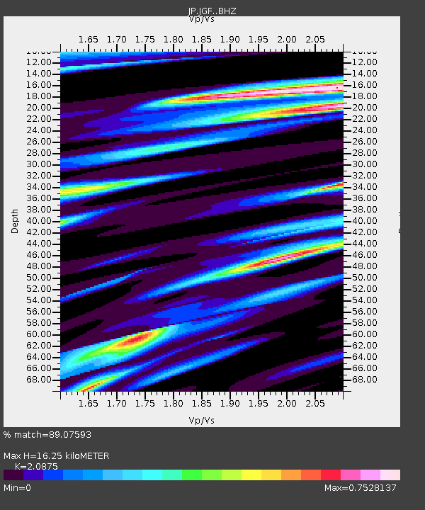
JGF Gifu Kurokawa - Earthquake Result Viewer
| Earthquake location: |
Minahassa Peninsula, Sulawesi |
| Earthquake latitude/longitude: |
0.0/119.8 |
| Earthquake time(UTC): |
2023/09/09 (252) 14:43:24 GMT |
| Earthquake Depth: |
9.9 km |
| Earthquake Magnitude: |
6.0 mww |
| Earthquake Catalog/Contributor: |
NEIC PDE/us |
|
| Network: |
JP Japan Meteorological Agency Seismic Network |
| Station: |
JGF Gifu Kurokawa |
| Lat/Lon: |
35.60 N/137.35 E |
| Elevation: |
580 m |
|
| Distance: |
39.0 deg |
| Az: |
23.015 deg |
| Baz: |
208.671 deg |
| Ray Param: |
0.075248286 |
| Estimated Moho Depth: |
16.25 km |
| Estimated Crust Vp/Vs: |
2.09 |
| Assumed Crust Vp: |
6.461 km/s |
| Estimated Crust Vs: |
3.095 km/s |
| Estimated Crust Poisson's Ratio: |
0.35 |
|
| Radial Match: |
89.07593 % |
| Radial Bump: |
332 |
| Transverse Match: |
65.396645 % |
| Transverse Bump: |
400 |
| SOD ConfigId: |
31937991 |
| Insert Time: |
2023-09-23 14:53:12.417 +0000 |
| GWidth: |
2.5 |
| Max Bumps: |
400 |
| Tol: |
0.001 |
|

Signal To Noise
| Channel | StoN | STA | LTA |
| JP:JGF: :BHZ:20230909T14:50:20.349993Z | 6.804947 | 6.965285E-7 | 1.02356196E-7 |
| JP:JGF: :BHN:20230909T14:50:20.349993Z | 4.618145 | 3.5153982E-7 | 7.612144E-8 |
| JP:JGF: :BHE:20230909T14:50:20.349993Z | 2.7695642 | 2.424127E-7 | 8.752739E-8 |
| Arrivals |
| Ps | 2.9 SECOND |
| PpPs | 7.3 SECOND |
| PsPs/PpSs | 10 SECOND |


