You are here: Home > Network List > TA - USArray Transportable Network (new EarthScope stations) Stations List
> Station S32A Newby Ranch, Pratt, KS, USA > Earthquake Result Viewer
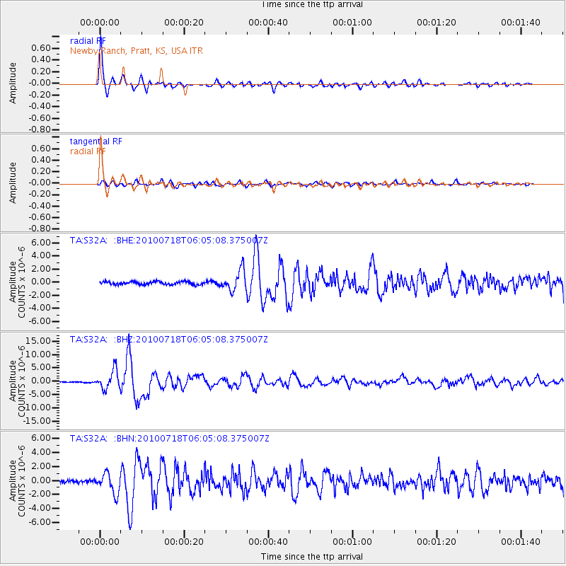
S32A Newby Ranch, Pratt, KS, USA - Earthquake Result Viewer
| Earthquake location: |
Fox Islands, Aleutian Islands |
| Earthquake latitude/longitude: |
52.9/-169.8 |
| Earthquake time(UTC): |
2010/07/18 (199) 05:56:44 GMT |
| Earthquake Depth: |
14 km |
| Earthquake Magnitude: |
6.3 MB, 6.7 MS, 6.6 MW, 6.6 MW |
| Earthquake Catalog/Contributor: |
WHDF/NEIC |
|
| Network: |
TA USArray Transportable Network (new EarthScope stations) |
| Station: |
S32A Newby Ranch, Pratt, KS, USA |
| Lat/Lon: |
37.70 N/98.94 W |
| Elevation: |
558 m |
|
| Distance: |
50.1 deg |
| Az: |
77.748 deg |
| Baz: |
311.692 deg |
| Ray Param: |
0.06827552 |
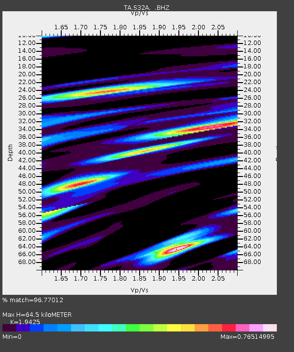
| Estimated Moho Depth: |
64.5 km |
| Estimated Crust Vp/Vs: |
1.94 |
| Assumed Crust Vp: |
6.426 km/s |
| Estimated Crust Vs: |
3.308 km/s |
| Estimated Crust Poisson's Ratio: |
0.32 |
|
| Radial Match: |
96.77012 % |
| Radial Bump: |
392 |
| Transverse Match: |
80.40195 % |
| Transverse Bump: |
400 |
| SOD ConfigId: |
319893 |
| Insert Time: |
2011-01-05 06:00:30.460 +0000 |
| GWidth: |
2.5 |
| Max Bumps: |
400 |
| Tol: |
0.001 |
|
Signal To Noise
| Channel | StoN | STA | LTA |
| TA:S32A: :BHZ:20100718T06:05:08.375007Z | 27.255747 | 3.6035676E-6 | 1.3221313E-7 |
| TA:S32A: :BHN:20100718T06:05:08.375007Z | 6.888548 | 1.4540461E-6 | 2.1108166E-7 |
| TA:S32A: :BHE:20100718T06:05:08.375007Z | 7.094435 | 1.6316116E-6 | 2.2998469E-7 |
| Arrivals |
| Ps | 10.0 SECOND |
| PpPs | 28 SECOND |
| PsPs/PpSs | 38 SECOND |


