You are here: Home > Network List > JP - Japan Meteorological Agency Seismic Network Stations List
> Station JTU Tsushima Kamiagata > Earthquake Result Viewer
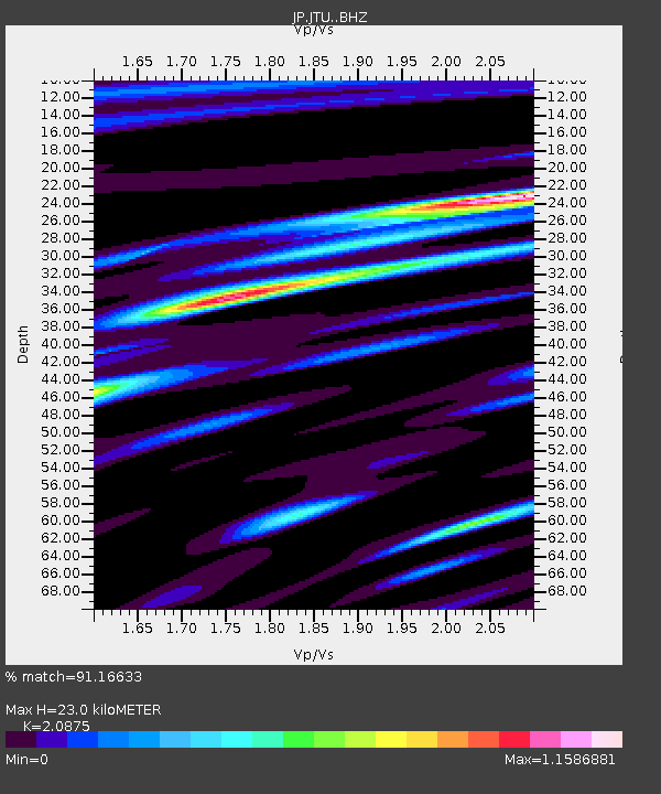
JTU Tsushima Kamiagata - Earthquake Result Viewer
| Earthquake location: |
Minahassa Peninsula, Sulawesi |
| Earthquake latitude/longitude: |
0.0/119.8 |
| Earthquake time(UTC): |
2023/09/09 (252) 14:43:24 GMT |
| Earthquake Depth: |
9.9 km |
| Earthquake Magnitude: |
6.0 mww |
| Earthquake Catalog/Contributor: |
NEIC PDE/us |
|
| Network: |
JP Japan Meteorological Agency Seismic Network |
| Station: |
JTU Tsushima Kamiagata |
| Lat/Lon: |
34.53 N/129.40 E |
| Elevation: |
70 m |
|
| Distance: |
35.5 deg |
| Az: |
13.751 deg |
| Baz: |
196.732 deg |
| Ray Param: |
0.07718922 |
| Estimated Moho Depth: |
23.0 km |
| Estimated Crust Vp/Vs: |
2.09 |
| Assumed Crust Vp: |
6.472 km/s |
| Estimated Crust Vs: |
3.1 km/s |
| Estimated Crust Poisson's Ratio: |
0.35 |
|
| Radial Match: |
91.16633 % |
| Radial Bump: |
356 |
| Transverse Match: |
77.06258 % |
| Transverse Bump: |
400 |
| SOD ConfigId: |
31937991 |
| Insert Time: |
2023-09-23 14:53:23.380 +0000 |
| GWidth: |
2.5 |
| Max Bumps: |
400 |
| Tol: |
0.001 |
|

Signal To Noise
| Channel | StoN | STA | LTA |
| JP:JTU: :BHZ:20230909T14:49:50.550005Z | 8.55471 | 1.8858109E-6 | 2.2044122E-7 |
| JP:JTU: :BHN:20230909T14:49:50.550005Z | 3.8849125 | 1.077083E-6 | 2.7724766E-7 |
| JP:JTU: :BHE:20230909T14:49:50.550005Z | 2.415661 | 4.260536E-7 | 1.7637142E-7 |
| Arrivals |
| Ps | 4.1 SECOND |
| PpPs | 10 SECOND |
| PsPs/PpSs | 14 SECOND |


