You are here: Home > Network List > TA - USArray Transportable Network (new EarthScope stations) Stations List
> Station T33A Patterson Ranch, Waldron, KS, USA > Earthquake Result Viewer
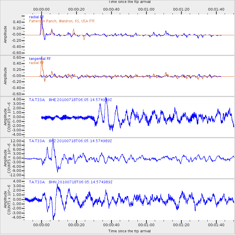
T33A Patterson Ranch, Waldron, KS, USA - Earthquake Result Viewer
| Earthquake location: |
Fox Islands, Aleutian Islands |
| Earthquake latitude/longitude: |
52.9/-169.8 |
| Earthquake time(UTC): |
2010/07/18 (199) 05:56:44 GMT |
| Earthquake Depth: |
14 km |
| Earthquake Magnitude: |
6.3 MB, 6.7 MS, 6.6 MW, 6.6 MW |
| Earthquake Catalog/Contributor: |
WHDF/NEIC |
|
| Network: |
TA USArray Transportable Network (new EarthScope stations) |
| Station: |
T33A Patterson Ranch, Waldron, KS, USA |
| Lat/Lon: |
37.08 N/98.24 W |
| Elevation: |
394 m |
|
| Distance: |
50.9 deg |
| Az: |
77.865 deg |
| Baz: |
312.185 deg |
| Ray Param: |
0.067732535 |
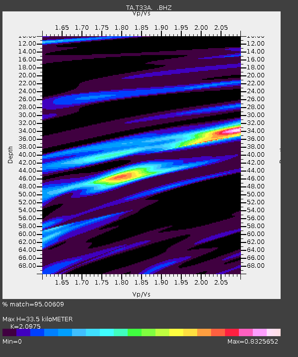
| Estimated Moho Depth: |
33.5 km |
| Estimated Crust Vp/Vs: |
2.10 |
| Assumed Crust Vp: |
6.426 km/s |
| Estimated Crust Vs: |
3.064 km/s |
| Estimated Crust Poisson's Ratio: |
0.35 |
|
| Radial Match: |
95.00609 % |
| Radial Bump: |
344 |
| Transverse Match: |
82.06079 % |
| Transverse Bump: |
400 |
| SOD ConfigId: |
319893 |
| Insert Time: |
2011-01-05 06:00:51.373 +0000 |
| GWidth: |
2.5 |
| Max Bumps: |
400 |
| Tol: |
0.001 |
|
Signal To Noise
| Channel | StoN | STA | LTA |
| TA:T33A: :BHZ:20100718T06:05:14.574989Z | 22.94542 | 2.996661E-6 | 1.3059953E-7 |
| TA:T33A: :BHN:20100718T06:05:14.574989Z | 4.4469633 | 1.1678876E-6 | 2.6262586E-7 |
| TA:T33A: :BHE:20100718T06:05:14.574989Z | 5.9203286 | 1.3628505E-6 | 2.3019845E-7 |
| Arrivals |
| Ps | 6.0 SECOND |
| PpPs | 15 SECOND |
| PsPs/PpSs | 21 SECOND |


