You are here: Home > Network List > TA - USArray Transportable Network (new EarthScope stations) Stations List
> Station G05D Wamic, OR, USA > Earthquake Result Viewer
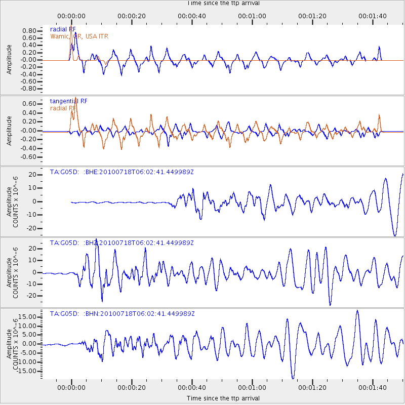
G05D Wamic, OR, USA - Earthquake Result Viewer
*The percent match for this event was below the threshold and hence no stack was calculated.
| Earthquake location: |
Fox Islands, Aleutian Islands |
| Earthquake latitude/longitude: |
52.9/-169.8 |
| Earthquake time(UTC): |
2010/07/18 (199) 05:56:44 GMT |
| Earthquake Depth: |
14 km |
| Earthquake Magnitude: |
6.3 MB, 6.7 MS, 6.6 MW, 6.6 MW |
| Earthquake Catalog/Contributor: |
WHDF/NEIC |
|
| Network: |
TA USArray Transportable Network (new EarthScope stations) |
| Station: |
G05D Wamic, OR, USA |
| Lat/Lon: |
45.24 N/121.32 W |
| Elevation: |
592 m |
|
| Distance: |
32.2 deg |
| Az: |
83.871 deg |
| Baz: |
301.458 deg |
| Ray Param: |
$rayparam |
*The percent match for this event was below the threshold and hence was not used in the summary stack. |
|
| Radial Match: |
75.70677 % |
| Radial Bump: |
400 |
| Transverse Match: |
70.54961 % |
| Transverse Bump: |
326 |
| SOD ConfigId: |
319893 |
| Insert Time: |
2011-01-05 06:01:27.959 +0000 |
| GWidth: |
2.5 |
| Max Bumps: |
400 |
| Tol: |
0.001 |
|
Signal To Noise
| Channel | StoN | STA | LTA |
| TA:G05D: :BHZ:20100718T06:02:41.449989Z | 22.871412 | 4.8223283E-6 | 2.1084523E-7 |
| TA:G05D: :BHN:20100718T06:02:41.449989Z | 3.5142734 | 7.562774E-7 | 2.1520164E-7 |
| TA:G05D: :BHE:20100718T06:02:41.449989Z | 5.338436 | 1.5289264E-6 | 2.8639968E-7 |
| Arrivals |
| Ps | |
| PpPs | |
| PsPs/PpSs | |


