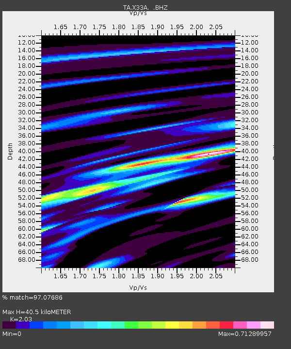
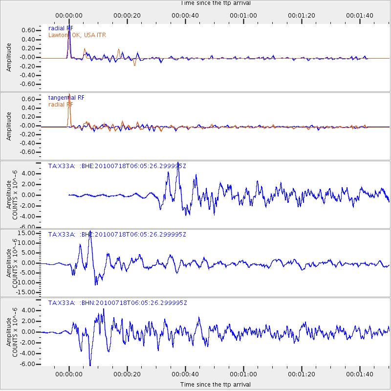
X33A Lawton, OK, USA - Earthquake Result Viewer

Earthquake location: Fox Islands, Aleutian Islands
Earthquake latitude/longitude: 52.9/-169.8
Earthquake time(UTC): 2010/07/18 (199) 05:56:44 GMT
Earthquake Depth: 14 km
Earthquake Magnitude: 6.3 MB, 6.7 MS, 6.6 MW, 6.6 MW
Earthquake Catalog/Contributor: WHDF/NEIC
Network: TA USArray Transportable Network (new EarthScope stations)
Station: X33A Lawton, OK, USA
Lat/Lon: 34.54 N/98.50 W
Elevation: 346 m
Distance: 52.5 deg
Az: 80.413 deg
Baz: 313.615 deg
Ray Param: 0.06671855
Estimated Moho Depth: 40.5 km
Estimated Crust Vp/Vs: 2.03
Assumed Crust Vp: 6.315 km/s
Estimated Crust Vs: 3.111 km/s
Estimated Crust Poisson's Ratio: 0.34
Radial Match: 97.07686 %
Radial Bump: 341
Transverse Match: 78.97675 %
Transverse Bump: 400
SOD ConfigId: 319893
Insert Time: 2011-01-05 06:01:39.954 +0000
GWidth: 2.5
Max Bumps: 400
Tol: 0.001

Signal To Noise

ChannelStoNSTALTA
TA:X33A: :BHZ:20100718T06:05:26.299995Z16.2537843.9237507E-62.4140536E-7
TA:X33A: :BHN:20100718T06:05:26.299995Z7.26076751.3718409E-61.8893883E-7
TA:X33A: :BHE:20100718T06:05:26.299995Z12.4089751.8051467E-61.4547106E-7
Arrivals
Ps6.9 SECOND
PpPs19 SECOND
PsPs/PpSs25 SECOND