You are here: Home > Network List > AG - Arkansas Seismic Network Stations List
> Station HHAR Hobbs,AR > Earthquake Result Viewer
HHAR Hobbs,AR - Earthquake Result Viewer
| Earthquake location: |
Western Brazil |
| Earthquake latitude/longitude: |
-8.1/-71.6 |
| Earthquake time(UTC): |
2019/01/05 (005) 19:25:38 GMT |
| Earthquake Depth: |
575 km |
| Earthquake Magnitude: |
6.8 Mww |
| Earthquake Catalog/Contributor: |
NEIC PDE/us |
|
| Network: |
AG Arkansas Seismic Network |
| Station: |
HHAR Hobbs,AR |
| Lat/Lon: |
36.28 N/93.94 W |
| Elevation: |
421 m |
|
| Distance: |
48.9 deg |
| Az: |
335.934 deg |
| Baz: |
150.022 deg |
| Ray Param: |
0.0663374 |
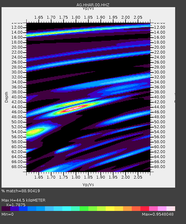
| Estimated Moho Depth: |
44.5 km |
| Estimated Crust Vp/Vs: |
1.79 |
| Assumed Crust Vp: |
6.53 km/s |
| Estimated Crust Vs: |
3.653 km/s |
| Estimated Crust Poisson's Ratio: |
0.27 |
|
| Radial Match: |
88.90419 % |
| Radial Bump: |
309 |
| Transverse Match: |
73.39363 % |
| Transverse Bump: |
400 |
| SOD ConfigId: |
3201911 |
| Insert Time: |
2019-01-19 19:34:48.804 +0000 |
| GWidth: |
2.5 |
| Max Bumps: |
400 |
| Tol: |
0.001 |
|

Signal To Noise
| Channel | StoN | STA | LTA |
| AG:HHAR:00:HHZ:20190105T19:33:02.490009Z | 66.74122 | 1.4161717E-5 | 2.1218847E-7 |
| AG:HHAR:00:HHN:20190105T19:33:02.490009Z | 11.01136 | 4.9491405E-6 | 4.494577E-7 |
| AG:HHAR:00:HHE:20190105T19:33:02.490009Z | 9.818989 | 4.237974E-6 | 4.3160998E-7 |
| Arrivals |
| Ps | 5.7 SECOND |
| PpPs | 18 SECOND |
| PsPs/PpSs | 24 SECOND |


