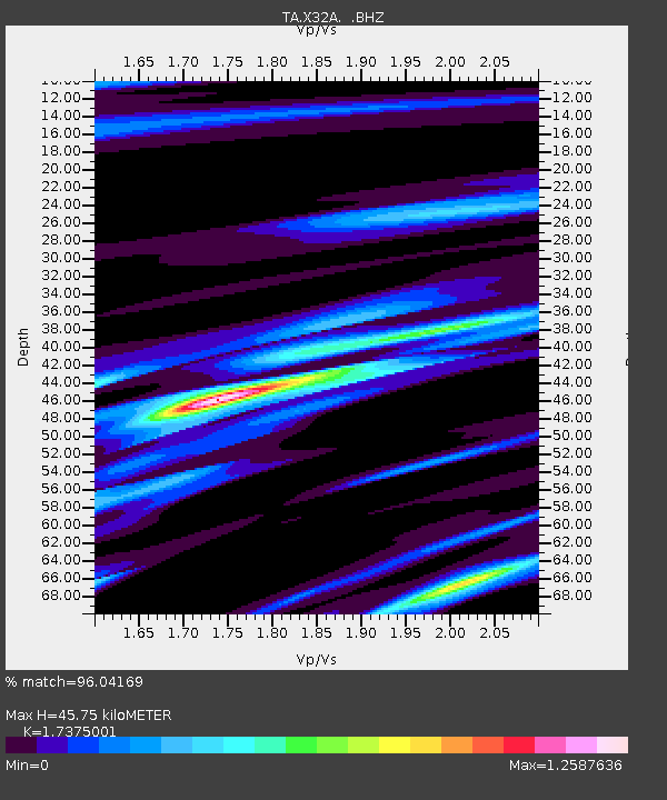
X32A Elmer, OK, USA - Earthquake Result Viewer

Earthquake location: Fox Islands, Aleutian Islands
Earthquake latitude/longitude: 52.9/-169.8
Earthquake time(UTC): 2010/07/18 (199) 05:56:44 GMT
Earthquake Depth: 14 km
Earthquake Magnitude: 6.3 MB, 6.7 MS, 6.6 MW, 6.6 MW
Earthquake Catalog/Contributor: WHDF/NEIC
Network: TA USArray Transportable Network (new EarthScope stations)
Station: X32A Elmer, OK, USA
Lat/Lon: 34.42 N/99.29 W
Elevation: 401 m
Distance: 52.1 deg
Az: 81.087 deg
Baz: 313.585 deg
Ray Param: 0.06696657
Estimated Moho Depth: 45.75 km
Estimated Crust Vp/Vs: 1.74
Assumed Crust Vp: 6.315 km/s
Estimated Crust Vs: 3.635 km/s
Estimated Crust Poisson's Ratio: 0.25
Radial Match: 96.04169 %
Radial Bump: 341
Transverse Match: 87.342186 %
Transverse Bump: 400
SOD ConfigId: 319893
Insert Time: 2011-01-05 06:01:58.811 +0000
GWidth: 2.5
Max Bumps: 400
Tol: 0.001

Signal To Noise

ChannelStoNSTALTA
TA:X32A: :BHZ:20100718T06:05:23.424995Z25.2191034.187126E-61.6602992E-7
TA:X32A: :BHN:20100718T06:05:23.424995Z7.120451.0851588E-61.5240032E-7
TA:X32A: :BHE:20100718T06:05:23.424995Z5.66758731.785917E-63.1511064E-7
Arrivals
Ps5.6 SECOND
PpPs19 SECOND
PsPs/PpSs24 SECOND