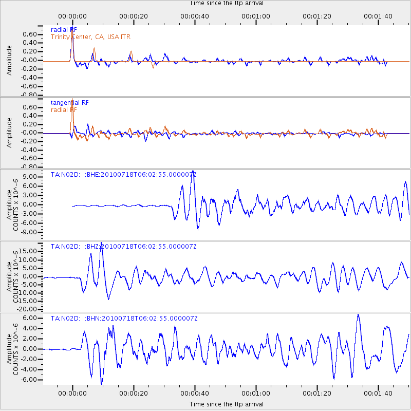
N02D Trinity Center, CA, USA - Earthquake Result Viewer
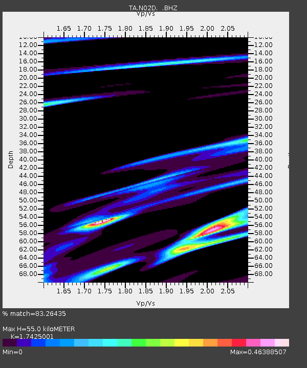
Earthquake location: Fox Islands, Aleutian Islands
Earthquake latitude/longitude: 52.9/-169.8
Earthquake time(UTC): 2010/07/18 (199) 05:56:44 GMT
Earthquake Depth: 14 km
Earthquake Magnitude: 6.3 MB, 6.7 MS, 6.6 MW, 6.6 MW
Earthquake Catalog/Contributor: WHDF/NEIC
Network: TA USArray Transportable Network (new EarthScope stations)
Station: N02D Trinity Center, CA, USA
Lat/Lon: 40.97 N/122.71 W
Elevation: 937 m
Distance: 33.7 deg
Az: 91.415 deg
Baz: 306.846 deg
Ray Param: 0.0780664
Estimated Moho Depth: 55.0 km
Estimated Crust Vp/Vs: 1.74
Assumed Crust Vp: 6.566 km/s
Estimated Crust Vs: 3.768 km/s
Estimated Crust Poisson's Ratio: 0.25
Radial Match: 83.26435 %
Radial Bump: 327
Transverse Match: 73.18622 %
Transverse Bump: 400
SOD ConfigId: 319893
Insert Time: 2011-01-05 06:02:59.087 +0000
GWidth: 2.5
Max Bumps: 400
Tol: 0.001

Signal To Noise

ChannelStoNSTALTA
TA:N02D: :BHZ:20100718T06:02:55.000007Z19.7699223.7003408E-61.8717023E-7
TA:N02D: :BHN:20100718T06:02:55.000007Z12.131961.4051667E-61.1582355E-7
TA:N02D: :BHE:20100718T06:02:55.000007Z10.8576361.8151057E-61.6717318E-7
Arrivals
Ps6.8 SECOND
PpPs21 SECOND
PsPs/PpSs28 SECOND