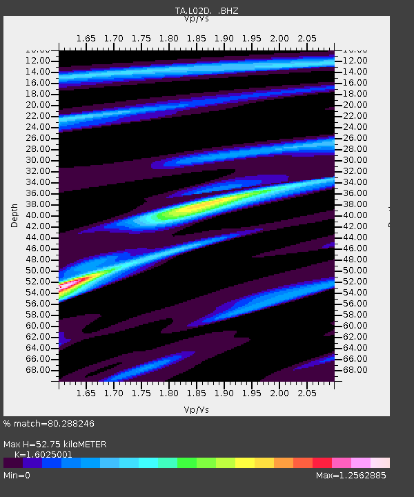
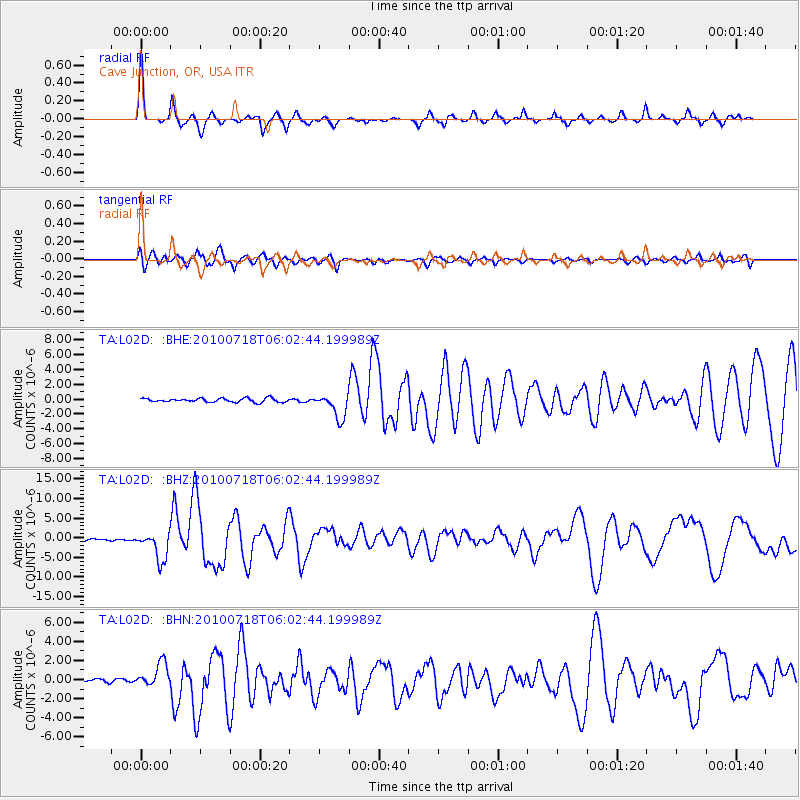
L02D Cave Junction, OR, USA - Earthquake Result Viewer

Earthquake location: Fox Islands, Aleutian Islands
Earthquake latitude/longitude: 52.9/-169.8
Earthquake time(UTC): 2010/07/18 (199) 05:56:44 GMT
Earthquake Depth: 14 km
Earthquake Magnitude: 6.3 MB, 6.7 MS, 6.6 MW, 6.6 MW
Earthquake Catalog/Contributor: WHDF/NEIC
Network: TA USArray Transportable Network (new EarthScope stations)
Station: L02D Cave Junction, OR, USA
Lat/Lon: 42.16 N/123.60 W
Elevation: 458 m
Distance: 32.5 deg
Az: 90.393 deg
Baz: 305.397 deg
Ray Param: 0.07862409
Estimated Moho Depth: 52.75 km
Estimated Crust Vp/Vs: 1.60
Assumed Crust Vp: 6.522 km/s
Estimated Crust Vs: 4.07 km/s
Estimated Crust Poisson's Ratio: 0.18
Radial Match: 80.288246 %
Radial Bump: 268
Transverse Match: 70.33885 %
Transverse Bump: 400
SOD ConfigId: 319893
Insert Time: 2011-01-05 06:03:36.380 +0000
GWidth: 2.5
Max Bumps: 400
Tol: 0.001

Signal To Noise

ChannelStoNSTALTA
TA:L02D: :BHZ:20100718T06:02:44.199989Z16.9824333.5949731E-62.1168775E-7
TA:L02D: :BHN:20100718T06:02:44.199989Z4.7725591.2826283E-62.6875063E-7
TA:L02D: :BHE:20100718T06:02:44.199989Z6.4517041.68768E-62.615867E-7
Arrivals
Ps5.3 SECOND
PpPs19 SECOND
PsPs/PpSs25 SECOND