You are here: Home > Network List > TA - USArray Transportable Network (new EarthScope stations) Stations List
> Station Z35A Perchaven, Sanger, TX, USA > Earthquake Result Viewer
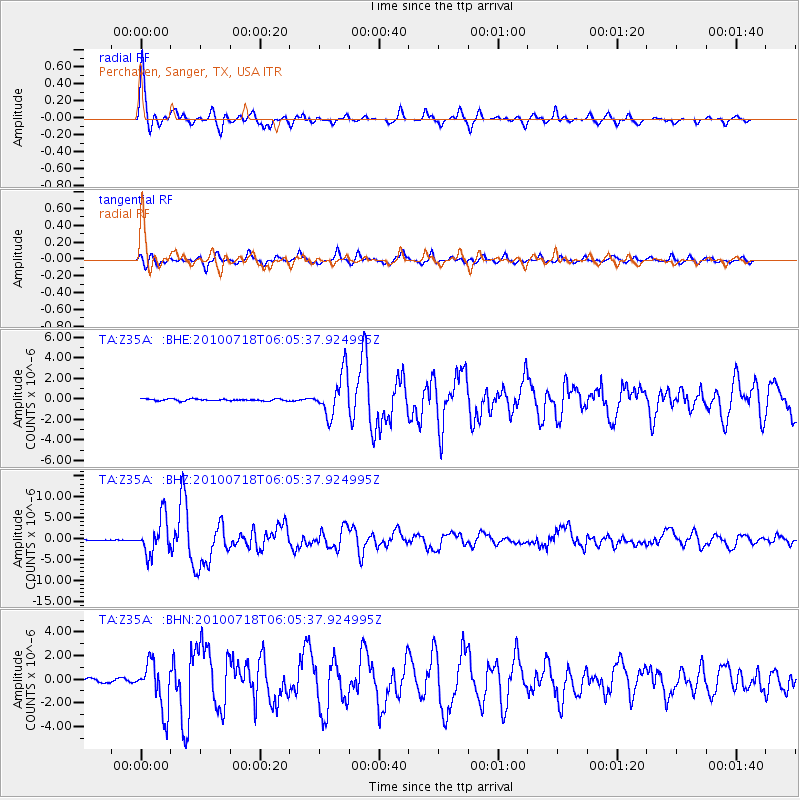
Z35A Perchaven, Sanger, TX, USA - Earthquake Result Viewer
| Earthquake location: |
Fox Islands, Aleutian Islands |
| Earthquake latitude/longitude: |
52.9/-169.8 |
| Earthquake time(UTC): |
2010/07/18 (199) 05:56:44 GMT |
| Earthquake Depth: |
14 km |
| Earthquake Magnitude: |
6.3 MB, 6.7 MS, 6.6 MW, 6.6 MW |
| Earthquake Catalog/Contributor: |
WHDF/NEIC |
|
| Network: |
TA USArray Transportable Network (new EarthScope stations) |
| Station: |
Z35A Perchaven, Sanger, TX, USA |
| Lat/Lon: |
33.33 N/97.25 W |
| Elevation: |
235 m |
|
| Distance: |
54.1 deg |
| Az: |
80.597 deg |
| Baz: |
314.418 deg |
| Ray Param: |
0.06566749 |
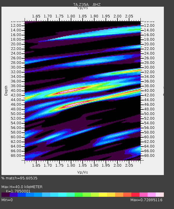
| Estimated Moho Depth: |
40.0 km |
| Estimated Crust Vp/Vs: |
1.79 |
| Assumed Crust Vp: |
6.38 km/s |
| Estimated Crust Vs: |
3.575 km/s |
| Estimated Crust Poisson's Ratio: |
0.27 |
|
| Radial Match: |
95.68535 % |
| Radial Bump: |
364 |
| Transverse Match: |
91.15366 % |
| Transverse Bump: |
400 |
| SOD ConfigId: |
319893 |
| Insert Time: |
2011-01-05 06:03:57.110 +0000 |
| GWidth: |
2.5 |
| Max Bumps: |
400 |
| Tol: |
0.001 |
|
Signal To Noise
| Channel | StoN | STA | LTA |
| TA:Z35A: :BHZ:20100718T06:05:37.924995Z | 43.255302 | 4.35426E-6 | 1.0066419E-7 |
| TA:Z35A: :BHN:20100718T06:05:37.924995Z | 17.317766 | 2.0003934E-6 | 1.1551105E-7 |
| TA:Z35A: :BHE:20100718T06:05:37.924995Z | 22.0011 | 2.0426287E-6 | 9.284212E-8 |
| Arrivals |
| Ps | 5.2 SECOND |
| PpPs | 17 SECOND |
| PsPs/PpSs | 22 SECOND |


